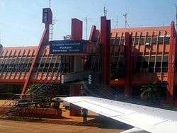
Libertador General José de San Martín Airport
| Libertador General José de San Martín Airport Aeropuerto de Posadas "Libertador General San Martín" | |||||||||||
|---|---|---|---|---|---|---|---|---|---|---|---|
 | |||||||||||
| Summary | |||||||||||
| Airport type | Public / Military | ||||||||||
| Operator | Aeropuertos Argentina 2000 | ||||||||||
| Serves | Posadas, Misiones Province, Argentina | ||||||||||
| Location | Ruta N12, Km 1336, Posadas (N3300) | ||||||||||
| Elevation AMSL | 430 ft / 131 m | ||||||||||
| Coordinates | 27°23′09″S 55°58′14″W / 27.38583°S 55.97056°WCoordinates: 27°23′09″S 55°58′14″W / 27.38583°S 55.97056°W | ||||||||||
| Map | |||||||||||
 PSS Location of airport in Argentina | |||||||||||
| Runways | |||||||||||
| |||||||||||
| Statistics (2017) | |||||||||||
| |||||||||||
Libertador General José de San Martín Airport (Spanish: Aeropuerto de Posadas "Libertador General San Martín") (IATA: PSS, ICAO: SARP) is located 7.5 km (4.7 mi) northwest of the center of Posadas, a city in the Misiones Province of Argentina. The airport covers an area of 329 hectares (813 acres) and is operated by Aeropuertos Argentina 2000 S.A.[1][2]
It has a 6,500 m² terminal, 67,740 m² of runways, and parking spaces for 100 vehicles. In 2007, it handled 65,019 passengers. At its peak in 1997, it handled 164,586 passengers.
Airlines and destinations
| Airlines | Destinations |
|---|---|
| Aerolíneas Argentinas | Buenos Aires-Aeroparque |
| Aerolíneas Argentinas Operated by Austral Líneas Aéreas | Buenos Aires-Aeroparque, Córdoba |
| Flybondi | Buenos Aires-El Palomar[6] |
Statistics
| Passengers | Change from previous year | Aircraft operations | Change from previous year | Cargo (metric tons) | Change from previous year | |
|---|---|---|---|---|---|---|
| 2001 | 128,000 | - | 2,666 | - | - | - |
| 2002 | 93,000 | 1,684 | - | - | ||
| 2003 | 101,787 | 1,297 | - | - | ||
| 2004 | 122,000 | 1,484 | - | - | ||
| 2005 | 113,000 | 1,482 | 564 | |||
| 2006 | 108,000 | 1,334 | 455 | |||
| 2007 | 65,019 | 863 | 313 | |||
| 2008 | 62,000 | 742 | 210 | |||
| 2009 | 114,000 | 1,325 | 345 | |||
| 2010 | 97,000 | 1,494 | 379 | |||
| 2011 | 93,000 | 1,319 | - | - | ||
| 2012 | 96,000 | 1,361 | - | - | ||
| 2013 | 111,000 | 1,431 | - | - | ||
| 2014 | 129,000 | 1,529 | - | - | ||
| 2015 | 175,000 | 1,948 | - | - | ||
| 2016 | 174,000 | 1,964 | - | - | ||
| 2017 | 209,000 | 2,190 | - | - | ||
| Source: Airports Council International. World Airport Traffic Statistics (Years 2005-2010) | ||||||
Accidents and incidents
On June 12, 1988, Austral Lineas Aereas Flight 46 undershot the runway, resulting in 22 deaths.
References
- 1 2 (in Spanish) "SARP - Posadas / Libertador Gral. D. José de San Martín" (PDF). Archived from the original (PDF) on 2011-05-31. at AIP Argentina
- 1 2 (in Spanish) Aeropuerto de Posadas "Libertador General San Martín" at Organismo Regulador del Sistema Nacional de Aeropuertos (ORSNA)
- ↑ Airport information for SARP at World Aero Data. Data current as of October 2006.Source: DAFIF.
- ↑ Airport information for PSS at Great Circle Mapper. Source: DAFIF (effective October 2006).
- ↑ Airport Council International 2010 World Airport Traffic Report
- ↑ Flybondi begin service to Posadas from April 2018
External links
- Posadas, PSS at Aeropuertos Argentina 2000 (official web site)
- Current weather for SARP at NOAA/NWS
- Accident history for PSS at Aviation Safety Network
This article is issued from
Wikipedia.
The text is licensed under Creative Commons - Attribution - Sharealike.
Additional terms may apply for the media files.