Porthkerry Viaduct
Porthkerry Viaduct is a railway viaduct near Barry in the Vale of Glamorgan, Wales.
The viaduct was designed and engineered by James Szlumper and William Szlumper, and was contracted to the Pethick Brothers to be built in the late nineteenth century in order to carry the Vale of Glamorgan Railway between Barry and Bridgend.[1] Construction started in 1894, but in August 1896 piers 10 and 11 sank approximately 4 feet into the ground, delaying construction.[2] The bridge was opened on 1 December 1897, but closed within a few days when one of the embankments began to give way.[3] A two and a half mile loop line diversion was quickly built around the north of the valley, whilst repairs and underpinning were entrusted to Price and Wills, builders of the no. 2 dock in Barry.[4] The viaduct eventually re-opened on 8 January 1900.[3]
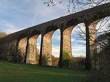
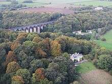
The viaduct has sixteen arches which vary between 45 and 50 feet (15 metres) in width and rising to a height of 110 feet (33 metres) and nowadays spans across Porthkerry Park.[5] It became Grade II listed in 1963.[6]
Originally designed as a route to bring coal to Barry Docks, the railway now carries coal in the other direction, to Aberthaw Power Station. It is also the passenger train route between Cardiff, Cardiff Airport and Bridgend.[7]
The Porthkerry Viaduct was designed to be an exact copy of the Shillamill Viaduct in Tavistock.[2]
References
| Wikimedia Commons has media related to Porthkerry Viaduct. |
- ↑ "Accident at Porthkerry Viaduct" (PDF). Board of Trade. p. 109. Retrieved 9 February 2017.
- 1 2 "Accident at Porthkerry Viaduct" (PDF). Board of Trade. p. 112. Retrieved 9 February 2017.
- 1 2 "Porthkerry Viaduct, Rhoose". The Transport Trust. Retrieved 15 December 2014.
- ↑ "Porthkerry Viaduct: Rebuilding to be Commenced". Barry Herald. p. 5. Retrieved 13 February 2017.
- ↑ "The viaduct and World War II". Vale of Glamorgan Council. Retrieved 15 December 2014.
- ↑ "Porthkerry Railway Viaduct (Partly in the Community of Rhoose), Porthkerry Park, Barry". British Listed Buildings. Retrieved 15 December 2014.
- ↑ Davies, Brian E. (2011), Wales: A Walk Through Time - Flat Holm to Brecon, Amberley Publishing, p. 122, ISBN 978-1848687073