Porkey, Pennsylvania
| Porkey, Pennsylvania | |
|---|---|
| Unincorporated community | |
 Porkey, Pennsylvania  Porkey, Pennsylvania | |
| Coordinates: 41°36′43″N 79°09′56″W / 41.61194°N 79.16556°WCoordinates: 41°36′43″N 79°09′56″W / 41.61194°N 79.16556°W | |
| Country | United States |
| State | Pennsylvania |
| County | Forest |
| Township | Howe |
| Elevation | 1,207 ft (368 m) |
| Time zone | UTC-5 (Eastern (EST)) |
| • Summer (DST) | UTC-4 (EDT) |
| GNIS feature ID | 1209901[1] |
Porkey is an unincorporated community in Howe Township, Forest County, Pennsylvania, United States.[1]
The settlement is located within the Allegheny National Forest along Pennsylvania Route 666, next to Tionesta Creek.
History
The early settlement contained three lumber mills and was described as "a small but active little town".[2]
Porkey was a stop on the Sheffield and Tionesta Railway, a now-abandoned 40 mi (64 km)-long railway that began operating in 1900.[3][4]
A wagon bridge was built across Tionesta Creek at Porkey in 1918.[2]
References
- 1 2 U.S. Geological Survey Geographic Names Information System: Porkey
- 1 2 Pavlansky, Joseph; Hanahan, Paula (2017). Forest County. Arcadia. p. 104.
- ↑ "Stations of the Past". West2k.Com. Retrieved August 4, 2017.
- ↑ "Sheffield & Tionesta Railway" (PDF). LaBelle Woodworking Company. Retrieved August 4, 2017.
Municipalities and communities of Forest County, Pennsylvania, United States | ||
|---|---|---|
| Borough | 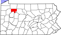 | |
| Townships | ||
| CDP | ||
| Unincorporated communities | ||
| Footnotes | ‡This populated place also has portions in an adjacent county or counties | |
This article is issued from
Wikipedia.
The text is licensed under Creative Commons - Attribution - Sharealike.
Additional terms may apply for the media files.