Clarington, Pennsylvania
| Clarington, Pennsylvania | |
|---|---|
| Unincorporated community | |
.jpg) Clarington Methodist Church | |
 Clarington  Clarington | |
| Coordinates: 41°19′57″N 79°07′23″W / 41.33250°N 79.12306°WCoordinates: 41°19′57″N 79°07′23″W / 41.33250°N 79.12306°W | |
| Country | United States |
| State | Pennsylvania |
| County | Forest |
| Township | Barnett |
| Elevation | 1,201 ft (366 m) |
| Time zone | UTC-5 (Eastern (EST)) |
| • Summer (DST) | UTC-4 (EDT) |
| ZIP code | 15828 |
| Area code(s) | 814 |
| GNIS feature ID | 1209504[1] |
Clarington is an unincorporated community in the township of Barnett, in Forest County, Pennsylvania, United States.[1] The community is located on the north bank of the Clarion River at the Pennsylvania Route 899 bridge, 12 miles (19 km) north of Brookville. Clarington had a post office until it closed on February 20, 2004; it still has its own ZIP code, 15828.[2][3]
References
- 1 2 "Clarington". Geographic Names Information System. United States Geological Survey.
- ↑ United States Postal Service. "USPS - Look Up a ZIP Code". Retrieved April 5, 2015.
- ↑ "Postmaster Finder - Post Offices by ZIP Code". United States Postal Service. Retrieved April 5, 2015.
| Wikimedia Commons has media related to Clarington, Pennsylvania. |
Municipalities and communities of Forest County, Pennsylvania, United States | ||
|---|---|---|
| Borough | 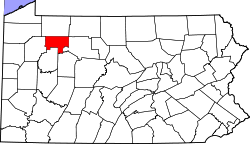 | |
| Townships | ||
| CDP | ||
| Unincorporated communities | ||
| Footnotes | ‡This populated place also has portions in an adjacent county or counties | |
This article is issued from
Wikipedia.
The text is licensed under Creative Commons - Attribution - Sharealike.
Additional terms may apply for the media files.