Ponshewaing, Michigan
| Ponshewaing, Michigan | |
|---|---|
| Census-designated place | |
 Ponshewaing Location within the state of Michigan | |
| Coordinates: 45°25′15″N 84°48′15″W / 45.42083°N 84.80417°WCoordinates: 45°25′15″N 84°48′15″W / 45.42083°N 84.80417°W | |
| Country | United States |
| State | Michigan |
| County | Emmet |
| Township | Littlefield |
| Area | |
| • Total | 0.09 sq mi (0.23 km2) |
| • Land | 0.09 sq mi (0.23 km2) |
| • Water | 0 sq mi (0 km2) |
| Elevation | 610 ft (186 m) |
| Population (2010) | |
| • Total | 69 |
| • Density | 784/sq mi (302.8/km2) |
| Time zone | UTC-5 (Eastern (EST)) |
| • Summer (DST) | UTC-4 (EDT) |
| Area code(s) | 231 |
| FIPS code | 26-65420[1] |
| GNIS feature ID | 635223[2] |
Ponshewaing is an unincorporated community and census-designated place (CDP) in Emmet County, Michigan, United States. As of the 2010 census it had a population of 69.[1]
Geography
Ponshewaing is located in southeastern Emmet County, in Littlefield Township, on the north shore of Crooked Lake. It is bordered to the west by Oden. U.S. Route 31 passes through the community, leading southwest 9 miles (14 km) to Petoskey, the county seat, and northeast 2 miles (3 km) to Alanson.
According to the U.S. Census Bureau, the Ponshewaing CDP has a total area of 0.09 square miles (0.23 km2), all of it land.[1]
References
- 1 2 3 "Geographic Identifiers: 2010 Demographic Profile Data (G001): Ponshewaing CDP, Michigan". U.S. Census Bureau, American Factfinder. Retrieved February 12, 2016.
- ↑ U.S. Geological Survey Geographic Names Information System: Ponshewaing, Michigan
Municipalities and communities of Emmet County, Michigan, United States | ||
|---|---|---|
| Cities | 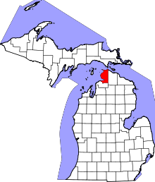 | |
| Villages | ||
| Townships | ||
| CDPs | ||
| Other unincorporated communities |
| |
| Indian reservation | ||
| Footnotes | ‡This populated place also has portions in an adjacent county or counties | |
This article is issued from
Wikipedia.
The text is licensed under Creative Commons - Attribution - Sharealike.
Additional terms may apply for the media files.