Pomezí nad Ohří
| Pomezí nad Ohří | |||
|---|---|---|---|
| Municipality | |||
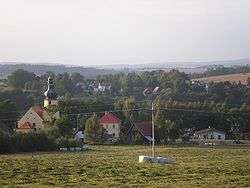 General view of the village | |||
| |||
 Pomezí nad Ohří Location in the Czech Republic | |||
| Coordinates: 50°05′09″N 12°17′02″E / 50.0857°N 12.284°ECoordinates: 50°05′09″N 12°17′02″E / 50.0857°N 12.284°E | |||
| Country |
| ||
| Region | Karlovy Vary Region | ||
| District | Cheb District | ||
| Area | |||
| • Total | 410 sq mi (10,70 km2) | ||
| Elevation | 1,535 ft (468 m) | ||
| Population (1 January 2014)[1] | |||
| • Total | 200 | ||
| • Density | 48/sq mi (18.7/km2) | ||
| Time zone | UTC+1 (CET) | ||
| • Summer (DST) | UTC+2 (CEST) | ||
| Postal code | 350 02 | ||
| NUTS 5 (municipality) | CZ0411 538868 | ||
| Website | Official website | ||

Pomezí nad Ohří (until 1950 German: Mühlbach) is a village and municipality in Cheb District in the Karlovy Vary Region of Czech Republic.
References
This article is issued from
Wikipedia.
The text is licensed under Creative Commons - Attribution - Sharealike.
Additional terms may apply for the media files.