Pollokshields East railway station
- For other Glasgow stations with similar names see Pollokshields and Pollokshields West.
| Pollokshields East | |
|---|---|
| Scottish Gaelic: Pollokshields an Ear[1] | |
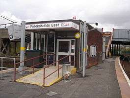 Looking north towards Glasgow Central | |
| Location | |
| Place | Pollokshields |
| Local authority | Glasgow |
| Coordinates | 55°50′27″N 4°16′08″W / 55.8407°N 4.2690°WCoordinates: 55°50′27″N 4°16′08″W / 55.8407°N 4.2690°W |
| Grid reference | NS580632 |
| Operations | |
| Station code | PLE |
| Managed by | Abellio ScotRail |
| Number of platforms | 2 |
|
Live arrivals/departures, station information and onward connections from National Rail Enquiries | |
| Annual rail passenger usage* | |
| 2012/13 |
|
| 2013/14 |
|
| 2014/15 |
|
| 2015/16 |
|
| 2016/17 |
|
| History | |
| Pre-grouping | Caledonian Railway |
| Post-grouping | LMS |
| 1 March 1886 | Opened[2][3] |
| 1 January 1917 | Closed[2] |
| 1 June 1919 | Reopened[2] |
| National Rail – UK railway stations | |
| * Annual estimated passenger usage based on sales of tickets in stated financial year(s) which end or originate at Pollokshields East from Office of Rail and Road statistics. Methodology may vary year on year. | |
|
| |
Pollokshields East railway station is one of two railway stations serving Pollokshields in Glasgow, Scotland. The station is managed by Abellio ScotRail and lies on the Cathcart Circle Line.
History
The station opened concurrently with the Cathcart District Railway, on 1 March 1886 and was the first of two stations on the Cathcart Circle serving the area to be built (nearby Pollokshields West opened eight years later on the western side of the Circle). It was closed as a wartime economy measure during World War 1 between January 1917 and June 1919. The 1923 Grouping saw ownership pass to the London, Midland and Scottish Railway and then onto the Scottish Region of British Railways in January 1948. Many trains over the route began to be worked by diesel multiple units from the summer of 1958, with overhead electrification following in 1962. A line voltage of 6.25kV A.C was used south of here initially due to clearance issues with the bridges & cuttings along the route, though this was subsequently increased to the standard 25kV in the early 1970s.
The original station building was badly damaged by fire in April 1976[4] and was subsequently rebuilt in contemporary style by British Rail.
Services
2016
A typical weekday and Saturday service is five trains per hour to Glasgow Central (one train per hour in each direction on the Cathcart Circle, two from Neilston and one from Newton via Kirkhill), two trains per hour to Neilston and one train per hour to Newton (the one other hourly train to/from Newton runs via Langside). A Sunday service is almost the same except the Cathcart Circle trains do not operate. As a result, only three trains per hour operate to Glasgow Central.[5]
Routes
| Preceding station | Following station | |||
|---|---|---|---|---|
| Queen's Park | Abellio ScotRail Cathcart Circle |
Glasgow Central | ||
| Historical railways | ||||
| Queen's Park Line and station open |
Caledonian Railway Cathcart District Railway |
Eglinton Street Line open; station closed | ||
References
Notes
- ↑ Brailsford 2017, Gaelic/English Station Index.
- 1 2 3 Butt (1995), page 187
- ↑ Kernahan (1980)
- ↑ "Chronology - Cathcart District Railway"Railscot; Retrieved 1 September 2016
- ↑ Table 223 National Rail timetable, May 2016
Sources
- Butt, R. V. J. (1995). The Directory of Railway Stations: details every public and private passenger station, halt, platform and stopping place, past and present (1st ed.). Sparkford: Patrick Stephens Ltd. ISBN 978-1-85260-508-7. OCLC 60251199.
- Brailsford, Martyn, ed. (December 2017) [1987]. Railway Track Diagrams 1: Scotland & Isle of Man (6th ed.). Frome: Trackmaps. ISBN 978-0-9549866-9-8.
- Jowett, Alan (March 1989). Jowett's Railway Atlas of Great Britain and Ireland: From Pre-Grouping to the Present Day (1st ed.). Sparkford: Patrick Stephens Ltd. ISBN 978-1-85260-086-0. OCLC 22311137.
- Jowett, Alan (2000). Jowett's Nationalised Railway Atlas (1st ed.). Penryn, Cornwall: Atlantic Transport Publishers. ISBN 978-0-906899-99-1. OCLC 228266687.
- Kernahan, Jack (1980). The Cathcart Circle. Falkirk, Stirlingshire: Scottish Railway Preservation Society. ISBN 0-9043-9601-0. OCLC 85045869.