Bridgeton railway station
| Bridgeton | |
|---|---|
| Scottish Gaelic: Baile na Drochaid[1] | |
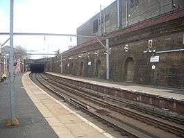 Bridgeton station, looking south east towards Dalmarnock | |
| Location | |
| Place | Bridgeton |
| Local authority | Glasgow |
| Coordinates | 55°50′54″N 4°13′30″W / 55.8484°N 4.2250°WCoordinates: 55°50′54″N 4°13′30″W / 55.8484°N 4.2250°W |
| Grid reference | NS607639 |
| Operations | |
| Station code | BDG |
| Managed by | Abellio ScotRail |
| Number of platforms | 2 |
|
Live arrivals/departures, station information and onward connections from National Rail Enquiries | |
| Annual rail passenger usage* | |
| 2012/13 |
|
| 2013/14 |
|
| 2014/15 |
|
| 2015/16 |
|
| 2016/17 |
|
| Passenger Transport Executive | |
| PTE | SPT |
| History | |
| 1 November 1895 | Opened |
| 5 October 1964 | Closed |
| 5 November 1979 | Re-opened |
| National Rail – UK railway stations | |
| * Annual estimated passenger usage based on sales of tickets in stated financial year(s) which end or originate at Bridgeton from Office of Rail and Road statistics. Methodology may vary year on year. | |
|
| |
Bridgeton railway station serves the Bridgeton district of Glasgow, Scotland and is a station on the Argyle Line, 1 3⁄4 miles (2.8 km) south east of Glasgow Central. The station is operated by Abellio ScotRail who also provide all train services.
History
It was opened on 1 November 1895 when the line between Glasgow Green and Rutherglen was opened by the Glasgow Central Railway. The station became a junction with the opening of the line to Carmyle and Kirkhill on 1 February 1897. Westbound services ran to Stobcross, from where they could proceed to Possil via Maryhill Central, Partickhill and points north via the connection to the Stobcross Railway or on to the Lanarkshire and Dunbartonshire Railway to Dumbarton and Balloch Central via Partick Central & Dalmuir Riverside.
In 1956 the line was re-signalled with colour light signals controlled from the re-equipped signal boxes at Bridgeton Cross Junction and Stobcross Junction. However, the station was closed along with both lines on 5 October 1964 as a result of the Beeching Axe. The tracks were subsequently lifted, but the station and tunnels were left intact.
As part of the Argyle Line project, the Rutherglen line platforms reopened on 5 November 1979, offering regular commuter services into Central Station (low level) and on towards the western suburbs.
Accidents and incidents
- On 2 February 1929, a passenger train was diverted into the bay platform due to a signalman's error. Several people were injured when the train crashed through the buffers.[2]
Services
1979
When the Argyle Line was opened in 1979, there were six trains an hour to the Hamilton Circle, from Dalmuir, with two services an hour going as far west as Dumbarton Central. The hourly service between Lanark and Milngavie ran non-stop through Bridgeton station.
2008
Four trains per hour daily head westbound towards Glasgow Central and beyond (Milngavie and Dalmuir) and eastbound towards Motherwell (with services onward to Lanark).
2015
The basic four trains per hour frequency remains unchanged, but since the December 2014 timetable recast southbound trains now run to either Motherwell via Hamilton Central or via Whifflet (though alternate services on that route terminate at Whifflet). On Sundays, southbound trains also serve Larkhall every hour and Balloch every 30 minutes.[3]
Routes
| Preceding station | Following station | |||
|---|---|---|---|---|
| Dalmarnock | Abellio ScotRail Argyle Line |
Argyle Street | ||
| Historical railways | ||||
| Parkhead Line and station closed |
Caledonian Railway Glasgow Central Railway |
Glasgow Green Line open; station closed | ||
| Dalmarnock | ||||
References
- ↑ Brailsford, Martyn, ed. (December 2017) [1987]. "Gaelic/English Station Index". Railway Track Diagrams 1: Scotland & Isle of Man (6th ed.). Frome: Trackmaps. ISBN 978-0-9549866-9-8.
- ↑ Earnshaw, Alan (1989). Trains in Trouble: Vol. 5. Penryn: Atlantic Books. p. 23. ISBN 0-906899-35-4.
- ↑ Table 225 National Rail timetable, May 2016
- Sources
- Butt, R. V. J. (1995). The Directory of Railway Stations: details every public and private passenger station, halt, platform and stopping place, past and present (1st ed.). Sparkford: Patrick Stephens Ltd. ISBN 978-1-85260-508-7. OCLC 60251199.
- Jowett, Alan (March 1989). Jowett's Railway Atlas of Great Britain and Ireland: From Pre-Grouping to the Present Day (1st ed.). Sparkford: Patrick Stephens Ltd. ISBN 978-1-85260-086-0. OCLC 22311137.