Pollenza
| Pollenza | |
|---|---|
| Comune | |
| Comune di Pollenza | |
 Pollenza | |
 Pollenza Location of Pollenza in Italy | |
| Coordinates: 43°16′N 13°21′E / 43.267°N 13.350°ECoordinates: 43°16′N 13°21′E / 43.267°N 13.350°E | |
| Country | Italy |
| Region | Marche |
| Province | Province of Macerata (MC) |
| Area | |
| • Total | 39.5 km2 (15.3 sq mi) |
| Population (Dec. 2004) | |
| • Total | 6,086 |
| • Density | 150/km2 (400/sq mi) |
| Demonym(s) | Pollentini |
| Time zone | UTC+1 (CET) |
| • Summer (DST) | UTC+2 (CEST) |
| Postal code | 62010 |
| Dialing code | 0733 |
| Website | Official website |
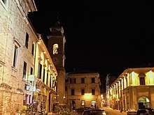
Pollenza plaza at night, March 2008
Pollenza is a comune (municipality) in the Province of Macerata in the Italian region Marche, located about 40 kilometres (25 mi) southwest of Ancona and about 9 kilometres (6 mi) southwest of Macerata. As of 31 December 2004, it had a population of 6,086 and an area of 39.5 square kilometres (15.3 sq mi).[1]
Among the religious buildings in town are:
- San Giuseppe: Baroque style church.
- Sant'Andrea Apostolo
- Abbazia di Rambona: remains of a Benedictine abbey, mainly the Church of Santa Maria Assunta, are located a few kilometers west of the town.
- San Biagio, Pollenza
Pollenza borders the following municipalities: Macerata, San Severino Marche, Tolentino, Treia.
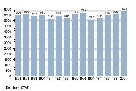
Demographic evolution
References
External links

This article is issued from
Wikipedia.
The text is licensed under Creative Commons - Attribution - Sharealike.
Additional terms may apply for the media files.