Petriolo
| Petriolo | |
|---|---|
| Comune | |
| Comune di Petriolo | |
 Petriolo Location of Petriolo in Italy | |
| Coordinates: 43°13′N 13°26′E / 43.217°N 13.433°ECoordinates: 43°13′N 13°26′E / 43.217°N 13.433°E | |
| Country | Italy |
| Region | Marche |
| Province | Province of Macerata (MC) |
| Area | |
| • Total | 15.6 km2 (6.0 sq mi) |
| Population (Dec. 2004) | |
| • Total | 2,063 |
| • Density | 130/km2 (340/sq mi) |
| Time zone | UTC+1 (CET) |
| • Summer (DST) | UTC+2 (CEST) |
| Postal code | 62010 |
| Dialing code | 0733 |
Petriolo is a comune (municipality) in the Province of Macerata in the Italian region Marche, located about 45 kilometres (28 mi) south of Ancona and about 9 kilometres (6 mi) south of Macerata. As of 31 December 2004, it had a population of 2,063 and an area of 15.6 square kilometres (6.0 sq mi).[1]
Petriolo borders the following municipalities: Corridonia, Loro Piceno, Mogliano, Tolentino, Urbisaglia.
Among the churches in the town are:
- Madonna della Misericordia
- Madonna della Grazie
- Santa Maria a Petriolo
- Santa Maria del Soccorso
- Santi Martino e Marco
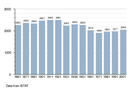
Demographic evolution
References

This article is issued from
Wikipedia.
The text is licensed under Creative Commons - Attribution - Sharealike.
Additional terms may apply for the media files.