Plimoth Plantation Highway
| Plimoth Plantation Highway | |
|---|---|
 | |
| Route information | |
| Length | 2.04 mi[1] (3.28 km) |
| Existed | 1951 – present |
| Major junctions | |
| West end |
|
| East end |
|
| Location | |
| Counties | Plymouth |
| Highway system | |
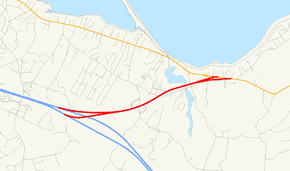
Plimoth Plantation Highway is a short unnumbered two-lane freeway with plastic stanchions posted on a rumbled asphalt median in Plymouth, Massachusetts.
Route description
The highway begins at Exit 4 off Route 3, a partial interchange which is accessible only from the southbound side from which there is a left exit. Motorists on Plimoth Plantation Highway headed toward Route 3 can enter that highway northbound only. However, motorists may use Exit 5 in order to reverse direction and ultimately travel southbound on Route 3. The highway proceeds east, serving Plimoth Plantation, Plymouth Beach and the village of Chiltonville. The highway ends at a special intersection in White Horse Beach and Manomet at Route 3A.
History
The first segment of Route 3 opened up in 1951 from what is now Exit 9 to Exit 4 and used Plimoth Plantation Highway temporarily to detour around the old Route 3 in Kingston and Plymouth, now renamed Route 3A, until 1957 when Route 3 south of Exit 4 opened and assumed its current alignment. An Act naming the two-mile (3 km) spur Plimoth Plantation Highway was approved on April 3, 1969, 18 years after the highway had opened.[2] The Act references the highway as being Exit 40, the old exit number before the Massachusetts Highway Department renumbered the exit in 1978.
Exit list
The entire route is in Plymouth, Plymouth County. All exits are unnumbered.
| mi | km | Destinations | Notes | ||
|---|---|---|---|---|---|
| 0.00 | 0.00 | Southbound exit and northbound entrance from Route 3; Exit 4 on Route 3 | |||
| Sandwich Road – Chiltonville, Plymouth Beach | |||||
| Plimoth Plantation | Westbound exit and entrance; opened seasonally | ||||
| Plimoth Plantation via River Street | Eastbound exit and entrance | ||||
| 2.04 | 3.28 | High-speed merge onto Route 3A south toward Manomet with two left-hand modified jughandles | |||
| 1.000 mi = 1.609 km; 1.000 km = 0.621 mi | |||||
Gallery
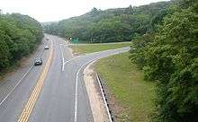 Looking eastward from the Sandwich Road Bridge
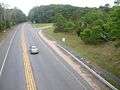 Looking westward from the Sandwich Road Bridge