Plessur Region
| Plessur Region Region Plessur | |
|---|---|
| District | |
 | |
| Country |
|
| Canton |
|
| Area | |
| • Total | 285.30 km2 (110.15 sq mi) |
| Population (2016) | |
| • Total | 41,730 |
| • Density | 150/km2 (380/sq mi) |
| Time zone | UTC+1 (CET) |
| • Summer (DST) | UTC+2 (CEST) |
| Municipalities | 6 |
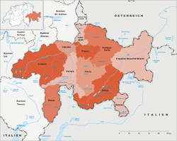
The Plessur Region is one of the eleven administrative districts in the canton of Graubünden in Switzerland. It had an area of 285.30 square kilometers (110.15 sq mi) and a population of 41,730 (as of 31 December 2016).[1]. It was created on 1 January 2017 as part of a reorganization of the Canton.[2]
Municipalities
| Municipalities in the Plessur Region | ||||
|---|---|---|---|---|
| Municipality | Population (31 December 2016)[1] |
Area (km²)[3] | ||
| Chur | 34,880 | 28.09 | ||
| Churwalden | 1,998 | 48.53 | ||
| Arosa | 3,219 | 154.79 | ||
| Maladers | 523 | 7.59 | ||
| Tschiertschen-Praden | 327 | 27.74 | ||
| Haldenstein | 1,030 | 18.56 | ||
References
- 1 2 Swiss Federal Statistical Office - STAT-TAB, online database – Ständige und nichtständige Wohnbevölkerung nach institutionellen Gliederungen, Geburtsort und Staatsangehörigkeit (in German) accessed 30 August 2017
- ↑ Swiss Federal Statistical Office - Amtliches Gemeindeverzeichnis der Schweiz - Mutationsmeldungen 2016 accessed 16 February 2017
- ↑ Arealstatistik Standard - Gemeindedaten nach 4 Hauptbereichen
This article is issued from
Wikipedia.
The text is licensed under Creative Commons - Attribution - Sharealike.
Additional terms may apply for the media files.