Plate, Germany
| Plate | ||
|---|---|---|
| ||
 Plate Location of Plate within Ludwigslust-Parchim district 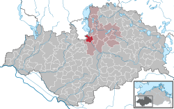 | ||
| Coordinates: 53°33′N 11°30′E / 53.550°N 11.500°ECoordinates: 53°33′N 11°30′E / 53.550°N 11.500°E | ||
| Country | Germany | |
| State | Mecklenburg-Vorpommern | |
| District | Ludwigslust-Parchim | |
| Municipal assoc. | Crivitz | |
| Government | ||
| • Mayor | Hans-Ekkehard Bauer | |
| Area | ||
| • Total | 22.05 km2 (8.51 sq mi) | |
| Elevation | 38 m (125 ft) | |
| Population (2017-12-31)[1] | ||
| • Total | 3,343 | |
| • Density | 150/km2 (390/sq mi) | |
| Time zone | CET/CEST (UTC+1/+2) | |
| Postal codes | 19086 | |
| Dialling codes | 03861 | |
| Vehicle registration | PCH | |
| Website | www.gemeinde-plate.de | |

Plate is a municipality in the Ludwigslust-Parchim district, in Mecklenburg-Vorpommern, Germany.
 Church
 Church
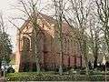 Church
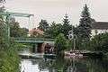 Stör-channel
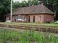 Train station
References
See also
- List of municipalities in Germany
- Towns in Mecklenburg-Vorpommern
This article is issued from
Wikipedia.
The text is licensed under Creative Commons - Attribution - Sharealike.
Additional terms may apply for the media files.