Platanias
| Platanias Πλατανιάς | |
|---|---|
 Platanias municipality | |
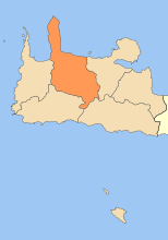
 Platanias Location within the region 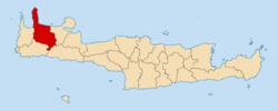 | |
| Coordinates: 35°31′N 23°54′E / 35.517°N 23.900°ECoordinates: 35°31′N 23°54′E / 35.517°N 23.900°E | |
| Country | Greece |
| Administrative region | Crete |
| Regional unit | Chania |
| Government | |
| • Mayor | Ioannis Malandrakis |
| Area | |
| • Municipality | 491.8 km2 (189.9 sq mi) |
| • Municipal unit | 74.9 km2 (28.9 sq mi) |
| Elevation | 10 m (30 ft) |
| Population (2011)[1] | |
| • Municipality | 16,874 |
| • Municipality density | 34/km2 (89/sq mi) |
| • Municipal unit | 5,275 |
| • Municipal unit density | 70/km2 (180/sq mi) |
| Community[1] | |
| • Population | 979 (2011) |
| Time zone | UTC+2 (EET) |
| • Summer (DST) | UTC+3 (EEST) |
| Postal code | 730 14 |
| Area code(s) | 28210 |
| Vehicle registration | ΧΝ, XB |
Platanias (Greek: Πλατανιάς) is a village and municipality on the Greek island of Crete. It is located about 10 km (6.2 mi) west from the city of Chania and east of Kastelli-Kissamos, on Chania Bay. The seat of the municipality is the village Gerani.[2] Platanias is a popular tourism village with a beach, several hotels, restaurants and souvenir shops. Not far from the coast is the island of Agioi Theodoroi.
Municipality
The municipality Platanias was formed at the 2011 local government reform by the merger of the following 4 former municipalities, that became municipal units:[2]
The municipality has an area of 491.780 km2 (189.877 sq mi), the municipal unit 74.932 km2 (28.931 sq mi).[3]
It lies within the Chania regional unit and is numbered 6 on the map of the Chania region. It is on the north coast, forming the eastern shore of Kissamos Bay (Kolpos Kissamou Kόλπος Κισσάμου), and the west and south shores of Chania Bay (Kolpos Chanion Κόλπος Χανίων). It is bordered by Kissamos (5) to the west, Kantanos-Selino (4) to the south, Chania (1) to the east, and Sfakia (7) in the southeast. Its northeast region is the Rodopos Peninsula (Chersonisos Rodopou Χερσόνησος Ροδωπού).
Historical population
| Year | Village | Municipal unit | Municipality |
|---|---|---|---|
| 1981 | 630 | - | - |
| 1991 | 719 | 5,044 | - |
| 2001 | 823 | 5,118 | - |
| 2011 | 979 | 5,275 | 16,874 |
Gallery
 Municipalities of Chania regional unit. Platanias: 6
References
- 1 2 "Απογραφή Πληθυσμού - Κατοικιών 2011. ΜΟΝΙΜΟΣ Πληθυσμός" (in Greek). Hellenic Statistical Authority.
- 1 2 Kallikratis law Greece Ministry of Interior (in Greek)
- ↑ "Population & housing census 2001 (incl. area and average elevation)" (PDF) (in Greek). National Statistical Service of Greece.
External links
See Chania Region for maps
Places adjacent to Platanias | ||||||||||
|---|---|---|---|---|---|---|---|---|---|---|
| ||||||||||
Administrative division of the Crete Region | ||
|---|---|---|
| Regional unit of Chania | 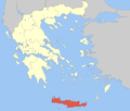 | |
| Regional unit of Heraklion | ||
| Regional unit of Lasithi | ||
| Regional unit of Rethymno | ||
| ||