La Plaine-des-Palmistes
| La Plaine-des-Palmistes | |
|---|---|
| Commune | |
 The town hall in Plaine-des-Palmistes | |
 | |
| Coordinates: 21°08′06″S 55°37′32″E / 21.1350°S 55.6256°ECoordinates: 21°08′06″S 55°37′32″E / 21.1350°S 55.6256°E | |
| Country | France |
| Overseas region and department | Réunion |
| Arrondissement | Saint-Benoît |
| Canton | Saint-Benoît-1 |
| Intercommunality | Réunion Est |
| Government | |
| • Mayor (2014-2020) | Marc Boyer |
| Area1 | 83.19 km2 (32.12 sq mi) |
| Population (2012)2 | 5,574 |
| • Density | 67/km2 (170/sq mi) |
| INSEE/Postal code | 97406 /97431 |
| Elevation |
720–2,402 m (2,362–7,881 ft) (avg. 1,008 m or 3,307 ft) |
|
1 French Land Register data, which excludes lakes, ponds, glaciers > 1 km2 (0.386 sq mi or 247 acres) and river estuaries. 2 Population without double counting: residents of multiple communes (e.g., students and military personnel) only counted once. | |
La Plaine-des-Palmistes is a commune in the French overseas department of Réunion.
Geography
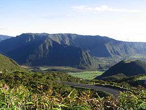
It lies in the eastern part of the island, on the RN3 road, south west of Saint-Benoît and northeast of the Col de Bellevue. It is known for its nearby forest and for the Biberon Falls. It lies close to the slopes of the Piton des Songes.
The communal territory is entirely located in the tops of the island. It borders Saint-Benoît, Sainte-Rose and Le Tampon.
See also
References
External links
- La Plaine-des-Palmistes at runweb.com (in French)
| Wikimedia Commons has media related to La Plaine-des-Palmistes. |
This article is issued from
Wikipedia.
The text is licensed under Creative Commons - Attribution - Sharealike.
Additional terms may apply for the media files.