Piz Sesvenna
| Piz Sesvenna | |
|---|---|
 Muntpitschen and Piz Sesvenna | |
| Highest point | |
| Elevation | 3,204 m (10,512 ft) |
| Prominence | 1,055 m (3,461 ft) [1] |
| Isolation | 21.5 km (13.4 mi) [2] |
| Parent peak | Ortler |
| Coordinates | 46°42′21.7″N 10°24′10.6″E / 46.706028°N 10.402944°ECoordinates: 46°42′21.7″N 10°24′10.6″E / 46.706028°N 10.402944°E |
| Geography | |
 Piz Sesvenna Location in Switzerland | |
| Location |
Graubünden, Switzerland (mountain partially in Italy) |
| Parent range | Sesvenna Range |
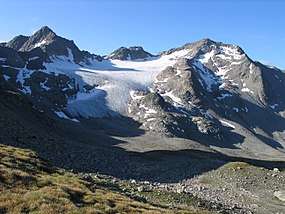
Piz Sesvenna is the highest mountain in the Sesvenna Range of the Alps. It lies between the Swiss canton of Graubünden and the Italian region of South Tyrol. The summit is located within Switzerland, very close to the Italian border and main watershed.
On the north side of Piz Sesvenna lies a glacier named Vadret da Sesvenna.
The closest locality is S-charl, south of Scuol in the Engadin valley.
See also
References
External links
This article is issued from
Wikipedia.
The text is licensed under Creative Commons - Attribution - Sharealike.
Additional terms may apply for the media files.