Piz Sardona
| Piz Sardona | |
|---|---|
| Surenstock | |
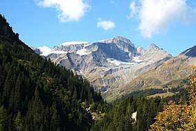 Piz Sardona from the Calfeisen valley (east side) | |
| Highest point | |
| Elevation | 3,056 m (10,026 ft) |
| Prominence | 113 m (371 ft) [1] |
| Parent peak | Piz Segnas |
| Coordinates | 46°55′22.2″N 9°15′5.4″E / 46.922833°N 9.251500°ECoordinates: 46°55′22.2″N 9°15′5.4″E / 46.922833°N 9.251500°E |
| Geography | |
 Piz Sardona Location in Switzerland | |
| Location |
Glarus/St. Gallen, Switzerland (mountain partially in Graubünden) |
| Parent range | Glarus Alps |
Piz Sardona (or Surenstock) is a mountain in the Glarus Alps, located on the border between the cantons Glarus and St. Gallen. The 3,056 metres high mountain overlooks the valleys of Elm (Glarus) and Calfeisen (St. Gallen). Less than one kilometre south of the summit lies the tripoint (3,000 metres) between the cantons of Glarus, St. Gallen and Graubünden. The summit itself is the northernmost point above 3,000 metres in Switzerland.
The massif is covered by a few small glaciers, the Sardonagletscher lying near the summit on the east side.
Piz Sardona is located within the Glarus thrust, a geologic UNESCO world heritage site, named Swiss Tectonic Arena Sardona.
The Foo Pass lies to the north of the Piz Sardona and carries a hiking trail from Weisstannen in St. Gallen to Elm in Glarus, forming part of the Alpine Pass Route between Sargans to Montreux.
References
External links