Piscataqua River Bridge
| Piscataqua River Bridge | |
|---|---|
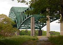
 The Piscataqua River Bridge seen from the Sarah Mildred Long Bridge | |
| Coordinates | 43°05′34″N 70°45′58″W / 43.092788°N 70.766158°WCoordinates: 43°05′34″N 70°45′58″W / 43.092788°N 70.766158°W |
| Carries |
|
| Crosses | Piscataqua River |
| Locale | Portsmouth, New Hampshire and Kittery, Maine |
| Official name | Piscataqua River Bridge |
| Maintained by | New Hampshire Department of Transportation[1] |
| ID number | 021702580012800[2] |
| Characteristics | |
| Design | Steel through arch bridge |
| Total length | 1372.5 m (4,503 ft) |
| Width | 29.9 m (98 ft) |
| Clearance above | 7.1 m (23.3 ft) |
| Clearance below | 41.1 m (134.8 ft) |
| History | |
| Opened | November 1, 1972[3] |
| Statistics | |
| Daily traffic | 60700 (1990) |
The Piscataqua River Bridge is a through arch bridge that crosses the Piscataqua River, connecting Portsmouth, New Hampshire with Kittery, Maine. Carrying six lanes of Interstate 95, the bridge is the third modern span and first fixed crossing of the Piscataqua between Portsmouth and Kittery. The two other spans, the Memorial Bridge and the Sarah Mildred Long Bridge, are both lift bridges, built to accommodate ship traffic along the Piscataqua. The high arch design of the Piscataqua River Bridge eliminates the need for a movable roadway.
History

The development of the Interstate Highway System required new roadbeds to be constructed and existing ones to be absorbed into the network. In New Hampshire, Interstate 95 was routed along the New Hampshire Turnpike, which had opened to traffic in 1950, and paralleled U.S. Route 1 through New Hampshire's Seacoast region from the Massachusetts border to the Turnpike's end at the Portsmouth Traffic Circle.[4] A gap remained between the traffic circle and the beginning of the Maine Turnpike on the other side of the Piscataqua River, filled by the US-1 Bypass. It crossed the river using the two-lane Sarah Mildred Long lift bridge, which was far from meeting Interstate Highway standards for four-lane highways and fixed spans.
The decision was made to extend I-95 north from the New Hampshire Turnpike at Portsmouth and south from the Maine Turnpike in Kittery, and join the roads with a high-speed fixed span over the Piscataqua. Work on the bridge began in 1968 and was completed in 1971, with the I-95 extension to it in Maine completed the following year.[5]
Tragedy struck the site about midway through construction. On June 24, 1970, two of the I-beams supporting the staging area on the Kittery side of the span gave way, plunging four workers 75 feet to their deaths and leaving another seven injured.[6] A memorial plaque was placed beneath the bridge on the Maine side, visible from Maine Route 103.[7]
The bridge was officially opened on November 1, 1972, in a ceremony attended by the Governor of New Hampshire, Walter R. Peterson Jr., and the Governor of Maine, Kenneth M. Curtis.[8][3]
See also
| Wikimedia Commons has media related to Piscataqua River Bridge. |


References
- ↑ NH General Court. "Section 228:40 Piscataqua River Bridge; Maintenance". Retrieved 2006-10-02.
- ↑ Nationalbridges.com. "National Bridge Inventory Bridges - 021702510010800". Archived from the original on 2007-09-27. Retrieved 2006-09-29.
- 1 2 Munson, Cecil B. (November 2, 1972). "Maine-N.H. Bridge Is Open". Biddeford-Saco Journal. Biddeford, Maine. p. 1. Retrieved March 31, 2018 – via newspapers.com.
- ↑ bostonroads.com. "New Hampshire Turnpike (I-95)". Retrieved 2006-10-02.
- ↑ MaineDOT. "Maine's Interstate turns 50!". Archived from the original on 2006-09-30. Retrieved 2006-10-03.
- ↑ "Four Workers Die, 7 Hurt in Fall at Bridge". Chicago Tribune. UPI. June 25, 1970. p. 38. Retrieved March 31, 2018 – via newspapers.com.
- ↑ "Eliot Rd, Kittery, Maine". September 2011. Retrieved March 31, 2018 – via Google Maps.
- ↑ "Governors open Maine-N.H. bridge". The Boston Globe. November 2, 1972. p. 13. Retrieved March 31, 2018 – via pqarchiver.com.
Bridges of the Piscataqua River | ||||
|---|---|---|---|---|
| ||||