Pinto Mountains
| Pinto Mountains | |
|---|---|
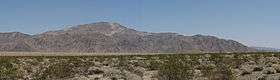 The Pinto Mountains seen from the south | |
| Highest point | |
| Elevation | 953 m (3,127 ft) |
| Geography | |
 location of Pinto Mountains in California [1] | |
| Country | United States |
| State | California |
| District | Riverside County |
| Range coordinates | 34°01′28″N 115°51′11″W / 34.02444°N 115.85306°WCoordinates: 34°01′28″N 115°51′11″W / 34.02444°N 115.85306°W |
| Topo map | USGS Humbug Mountain |
The Pinto Mountains are found in southern California, USA, at the north-central part of Joshua Tree National Park. The range reaches an elevation of 1,390 meters (4,560 ft) southeast of the city of Twentynine Palms. The range is made up of dark gneiss, and the creosote bush is the dominant plant in the area.
References
This article is issued from
Wikipedia.
The text is licensed under Creative Commons - Attribution - Sharealike.
Additional terms may apply for the media files.