Pino Torinese
| Pino Torinese | ||
|---|---|---|
| Comune | ||
| Comune di Pino Torinese | ||
 | ||
| ||
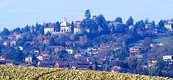
 Pino Torinese Location of Pino Torinese in Italy | ||
| Coordinates: 45°2′36.56″N 7°46′21.20″E / 45.0434889°N 7.7725556°E | ||
| Country | Italy | |
| Region | Piedmont | |
| Metropolitan city | Turin (TO) | |
| Frazioni | Cento Croci, San Felice, Valle Ceppi, Tetti Miglioretti, Monte Aman | |
| Government | ||
| • Mayor | Alessandra Tosi | |
| Area | ||
| • Total | 21.9 km2 (8.5 sq mi) | |
| Elevation | 550 m (1,800 ft) | |
| Population (31 November 2017)[1] | ||
| • Total | 8,329 | |
| • Density | 380/km2 (990/sq mi) | |
| Demonym(s) | Pinesi | |
| Time zone | UTC+1 (CET) | |
| • Summer (DST) | UTC+2 (CEST) | |
| Postal code | 10025 | |
| Dialing code | 011 | |
| Patron saint | St. Andrew | |
| Website | Official website | |

Pino Torinese is a comune (municipality) in the Metropolitan City of Turin in the Italian region Piedmont, located about 6 kilometres (4 mi) southeast of Turin.
Pino Torinese borders the following municipalities: Turin, Baldissero Torinese, Chieri, Pecetto Torinese, and Cambiano.
It is the site of the Observatory of Turin, founded in 1759.
The Associazione Cultura Giapponese di Torino had its offices in Pino Torinese. It operates a Japanese weekend school.[2]
References
External links

This article is issued from
Wikipedia.
The text is licensed under Creative Commons - Attribution - Sharealike.
Additional terms may apply for the media files.