Barbania
| Barbania | ||
|---|---|---|
| Comune | ||
| Comune di Barbania | ||
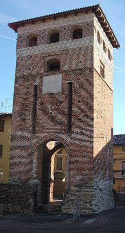 The surviving entrance to the medieval ricetto or fortress | ||
| ||
 Barbania Location of Barbania in Italy | ||
| Coordinates: 45°18′N 7°38′E / 45.300°N 7.633°E | ||
| Country | Italy | |
| Region | Piedmont | |
| Metropolitan city | Turin (TO) | |
| Frazioni | Boschi, Colli, Fandaglia, Gianotti, Perrero, Piana, Seita, Vignali, Zaccaria | |
| Government | ||
| • Mayor | Giovanni Battista Drovetti | |
| Area | ||
| • Total | 12.80 km2 (4.94 sq mi) | |
| Elevation | 385 m (1,263 ft) | |
| Population (1-1-2017)[1] | ||
| • Total | 1,603 | |
| • Density | 130/km2 (320/sq mi) | |
| Demonym(s) | Barbaniese(i) | |
| Time zone | UTC+1 (CET) | |
| • Summer (DST) | UTC+2 (CEST) | |
| Postal code | 10070 | |
| Dialing code | 011 | |
| Website | Official website | |
Barbania is a comune (municipality) in the Metropolitan City of Turin in the Italian region Piedmont, located about 25 kilometres (16 mi) north of Turin. It is in the middle of Malone river plain.
Barbania borders the following municipalities: Rivara, Busano, Rocca Canavese, Levone, and Vauda Canavese. It originates from a Salassi Celtic village founded around the late 5th century BC. In the Middle Ages it was a free commune (11th century), until it was conquered by Philip I of Piedmont in 1305; thenceforth its history is connected with the Duchy of Savoy.
References

This article is issued from
Wikipedia.
The text is licensed under Creative Commons - Attribution - Sharealike.
Additional terms may apply for the media files.