Pinbarren, Queensland
| Pinbarren Sunshine Coast, Queensland | |||||||||||||||
|---|---|---|---|---|---|---|---|---|---|---|---|---|---|---|---|
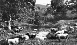 Jersey Cattle on the banks of Pinbarren Creek, ~1931 | |||||||||||||||
| Population | 343 (2016 census)[1] | ||||||||||||||
| Established | 1890 | ||||||||||||||
| Postcode(s) | 4568 | ||||||||||||||
| Location | 35 km (22 mi) WNW of Noosa Heads | ||||||||||||||
| LGA(s) | Shire of Noosa | ||||||||||||||
| State electorate(s) | Noosa | ||||||||||||||
| Federal Division(s) | Wide Bay | ||||||||||||||
| |||||||||||||||
Coordinates: 26°20′06″S 152°50′56″E / 26.335°S 152.849°E
Pinbarren is a suburb on the Sunshine Coast, Queensland, Australia, 35 kilometres (22 mi) from the centre of Noosa Heads. It is located at the foot of Mount Pinbarren. It is within the local government area of Shire of Noosa (between 2008 and 2013 it was within Sunshine Coast Region). Its southern boundary is marked by Six Mile Creek. At the 2011 Australian Census the suburb recorded a population of 343.[1]
Mount Pinbarren is located in Mount Pinbarren National Park which was established in 1929.
References
- 1 2 Australian Bureau of Statistics (27 June 2017). "Pinbarren (State Suburb)". 2016 Census QuickStats. Retrieved 7 August 2018.

External links
![]()
This article is issued from
Wikipedia.
The text is licensed under Creative Commons - Attribution - Sharealike.
Additional terms may apply for the media files.