Pilis Mountains
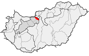

The Pilis Mountains is a mountainous region in the Transdanubian Mountains.[1] Its highest peak is the Pilis with 756 meters (2,480 ft). It is a popular vacation destination in Hungary.[2][3] The name comes from Slavic Pleš - bald (mountain).[4][5]
The Pilis Mountains used to be a famous hunting ground for Hungarian Kings. Many hunting lodges have survived. Favorite places include the villages and hills between Pilis Mountains and Visegrad Hills, especially Pilisszentkereszt. Here, a road leads to Dobogó-ko (699 m above sea level), where one can admire an outstanding panoramic view on the Danube Bend. In the Pilis Mountains, there are three mountains' locations show exact similarity to the arrangements of the three stars of Orion's. These are as follows: the Árpádvár, the Ram-hill, and the High (Mage)- mountain. Dobogókő is a climatic health place, hiking and ski resort, with one of the most beautiful panoramic views in Hungary. Some sites worth visiting are:
- Rám-szakadék (Rám Canyon)
- Thirring-szikla (Thirring Rock, Turul Roundroute)
- Ferenczy-szikla (Ferenczy Rock, which is believed to be the Heart Chakra of Earth)
- Zsivány-szikla (Rogue Rock)
- Vadálló-kövek (Game Watch Boulders)
- Prédikálószék (Preacher’s Stool) with its gorgeous view
- Pilis-tető (Pilis Summit), the second highest point of Transdanubia.
Caves
- One of its caves is called Heart Hungarian: Szív. In 2013 it was under exploration.
References
- ↑ "Bakony Mountains". Encyclopædia Britannica. Encyclopædia Britannica, Inc. 2008. Retrieved 2008-05-26.
- ↑ "Hungary - Sports and recreation". Encyclopædia Britannica. Encyclopædia Britannica, Inc. 2008. Retrieved 2008-05-26.
- ↑ "Hungarian Rhapsody". Forbes. 2005-08-26. Retrieved 2008-05-26.
- ↑ Stanislav, Ján (2004). Slovenský juh v stredoveku II (in Slovak). Slovenské literárne centrum. p. 353. ISBN 80-88878-89-6.
- ↑ Kiss, Lajos (1978). Földrajzi nevek etimológiai szótára (in Hungarian). Budapest: Akadémiai. p. 513.
| West-Hungarian Borderland |
|  |
|---|---|---|
| Little Hungarian Plain |
| |
| Transdanubia |
| |
| Transdanubian Mountains |
| |
| Transdanubian Hills |
| |
| North Hungarian Mountains | ||
| Great Hungarian Plain | ||
Coordinates: 47°43′55″N 18°55′07″E / 47.7319°N 18.9185°E