Cserhát

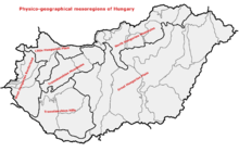
Location of the Cserhát Mountains proper within physical subdivisions of Hungary

Cserhát Mountains near the ethnographic village of Hollókő
Cserhát ([ˈtʃɛrhaːt]) is a mountain range in Hungary, part of the North Hungarian Mountains, divided between Pest and Nógrád counties. Its highest point is the Naszály with an elevation of 654 metres above sea level.
Cserhát stretches from Cserhátalja to the valley of the Ipoly (Slovak: Ipeľ) river. Its central part is mountainous, covered with forests, while its southern and northern parts are hilly.
With regard to architecture, the territory is rich in castles and Hollókő, an ethnographic village is located there.
See also
| West-Hungarian Borderland |
|  |
|---|---|---|
| Little Hungarian Plain |
| |
| Transdanubia |
| |
| Transdanubian Mountains |
| |
| Transdanubian Hills |
| |
| North Hungarian Mountains | ||
| Great Hungarian Plain | ||
This article is issued from
Wikipedia.
The text is licensed under Creative Commons - Attribution - Sharealike.
Additional terms may apply for the media files.