Piesting
| Piesting | |
|---|---|
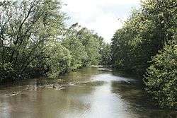 The Piesting near Sollenau | |
| Country | Austria |
| Physical characteristics | |
| River mouth |
Fischa at Gramatneusiedl 48°01′12″N 16°29′40″E / 48.0201°N 16.4944°ECoordinates: 48°01′12″N 16°29′40″E / 48.0201°N 16.4944°E |
| Length | 77.1 km (47.9 mi) [1] |
| Basin features | |
| Progression | Fischa→ Danube→ Black Sea |
The Piesting is a river in southern Lower Austria. Its sources are the Kalte Gang, the Steinapiesting, and the Längapiesting, which begin south of the Schneeberg.
These creeks meet in Gutenstein in the Wienerwald. From there the Piesting flows east through Markt Piesting and Wöllersdorf and into the Viennese Basin. The Piesting meets the Fischa at Gramatneusiedl.
The tributary of the Myrabach stream discharges at Pernitz into the Piesting. Between the Hohe Mandling (967 m) in the north and the Großer Kitzberg (771 m) in the south, the Piesting breaks through the Quarb (47°53′0″N 15°59′38″E / 47.88333°N 15.99389°E), a rocky ravine, and flows further eastwards through Markt Piesting and Wöllersdorf into the Vienna Basin. Near Gramatneusiedl the Piesting enters the Fischa.
The valley west of the Thermenlinie in the Vienna Woods is known as the Piesting Valley.
See also
| Wikimedia Commons has media related to Piesting. |
References
- ↑ Niederösterreich Atlas (Lower Austria)