Wöllersdorf-Steinabrückl
| Wöllersdorf-Steinabrückl | ||
|---|---|---|
| ||
 Wöllersdorf-Steinabrückl Location within Austria | ||
| Coordinates: 47°52′00″N 16°10′00″E / 47.86667°N 16.16667°ECoordinates: 47°52′00″N 16°10′00″E / 47.86667°N 16.16667°E | ||
| Country | Austria | |
| State | Lower Austria | |
| District | Wiener Neustadt-Land | |
| Government | ||
| • Mayor | Hubert Schneider (SPÖ) | |
| Area | ||
| • Total | 14.46 km2 (5.58 sq mi) | |
| Elevation | 315 m (1,033 ft) | |
| Population (1 January 2016)[1] | ||
| • Total | 4,289 | |
| • Density | 300/km2 (770/sq mi) | |
| Time zone | UTC+1 (CET) | |
| • Summer (DST) | UTC+2 (CEST) | |
| Postal codes |
2752 (Wöllersdorf) 2751 (Steinabrückl) | |
| Area codes |
02633 (Wöllersdorf) 02622 (Steinabrückl) | |
| Vehicle registration | WB | |
| Website | www.woellersdorf-steinabrueckl.at | |

Wöllersdorf-Steinabrückl is a municipality in the district of Wiener Neustadt-Land in the Austrian state of Lower Austria.
History
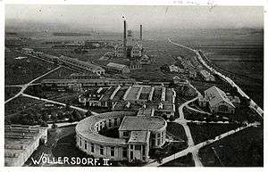
Old ordnance factory
Old ordnance factory in the municipality was used as a concentration camp from 1933 until 1938.
Population
| Historical population | ||
|---|---|---|
| Year | Pop. | ±% |
| 1869 | 2,235 | — |
| 1880 | 2,372 | +6.1% |
| 1890 | 2,495 | +5.2% |
| 1900 | 2,629 | +5.4% |
| 1910 | 3,178 | +20.9% |
| 1923 | 3,514 | +10.6% |
| 1934 | 3,079 | −12.4% |
| 1939 | 2,830 | −8.1% |
| 1951 | 2,561 | −9.5% |
| 1961 | 2,386 | −6.8% |
| 1971 | 2,451 | +2.7% |
| 1981 | 2,690 | +9.8% |
| 1991 | 3,190 | +18.6% |
| 2001 | 3,797 | +19.0% |
| 2011 | 4,171 | +9.8% |
References
- ↑ Statistik Austria - Bevölkerung zu Jahresbeginn 2002-2016 nach Gemeinden (Gebietsstand 1.1.2016) for Wöllersdorf-Steinabrückl.
| Wikimedia Commons has media related to Wöllersdorf-Steinabrückl. |
This article is issued from
Wikipedia.
The text is licensed under Creative Commons - Attribution - Sharealike.
Additional terms may apply for the media files.