Piesau (river)
| Piesau | |
|---|---|
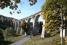 Rail viaduct over the Piesau valley in Lichte (Wallendorf) close to the station Lichte Ost | |
| Country | Germany |
| Physical characteristics | |
| Main source |
South of the municipality of Piesau on the Rennsteig 750.9 m (2,464 ft) 50°30′08″N 11°13′09.9″E / 50.50222°N 11.219417°E |
| River mouth |
Lichte 50°31′34.07″N 11°11′34.08″E / 50.5261306°N 11.1928000°ECoordinates: 50°31′34.07″N 11°11′34.08″E / 50.5261306°N 11.1928000°E |
| Length | 7 km (4.3 mi) |
| Discharge |
|
| Basin features | |
| Progression | Lichte→ Schwarza→ Saale→ Elbe→ North Sea |
| Basin size | Rennsteig |
The Piesau is a right tributary of the river Lichte in Thuringia, Germany, and is approximately 7 km long. The name is derived from the municipality of Piesau.
Sources
The Piesau has its source close to the Rennsteig south of the municipality of Piesau in the Thuringian Highland.
Course
The Piesau rises as the Piesau Kieselbach and flows through the Thuringian Forest Nature Park, first from the Rennsteig, to the municipality of Piesau. Then it merges with the Bärenbach, becoming the Piesau River, and flows north to the municipality of Lichte (Bock-und-Teich), the so-called Piesauknie.
After that it flows alongside the street Saalfelder Strasse in parallel to B 281. In the centre of Lichte (in the Wallendorf section) the Piesau joins the Lichte River. In Wallendorf, close to the Lichte East railway station, it flows under the rail viaduct over the Piesau Valley.
Name
According to old written traditions, the original name of the river was Schmiedebach. This referred to the lower reaches, in the area of the Bock-und-Teich section of the municipality of Lichte. The present-day name of the river appears only after the foundation of the municipality of Piesau in 1627, derived from the name of the founder, Pisa.[1]
Tributaries
| Left | Kupfertalbach | ||
| Right | Baerenbach | Kulmbach | Taubenbach |
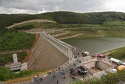
Below the municipality of Lichte, the river passes through a roughly 3 km long and 200 m deep gorge, which ends in the Deesbach Forebay (height 42.5 m). This is followed by the Leibis-Lichte Dam.
Particularity
The Piesau and Lichte have unusually steep and deep gorges, the difference between hill tops and valley bottoms often exceeding 100 m.
The Piesau and Lichte and their tributaries in the surrounding valleys have been known for centuries for deposits of placer gold and are considered the most significant sources of gold in Germany. Recreational placer miners continue to find occasional gold nuggets.[2]
See also
References
- ↑ Johann G. Brückner, Landeskunde des Herzogthums Meiningen, Meiningen: Brückner and Renner, 1851, p. 592.
- ↑ Rich. Christian Kreibich, Goldwäscherei (in German)