Pierpont, Monongalia County, West Virginia
| Pierpont, West Virginia | |
|---|---|
| Unincorporated community | |
 Pierpont, West Virginia  Pierpont, West Virginia | |
| Coordinates: 39°39′14″N 79°53′22″W / 39.65389°N 79.88944°WCoordinates: 39°39′14″N 79°53′22″W / 39.65389°N 79.88944°W | |
| Country | United States |
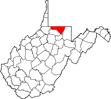
| State | West Virginia |
| County | Monongalia |
| Elevation | 1,247 ft (380 m) |
| Time zone | UTC-5 (Eastern (EST)) |
| • Summer (DST) | UTC-4 (EDT) |
| Area code(s) | 304 & 681 |
| GNIS feature ID | 1544807[1] |
Pierpont is an unincorporated community in Monongalia County, West Virginia, United States. Pierpont is located on County Route 67 near Interstate 68, 3.9 miles (6.3 km) east-northeast of Morgantown.[2]
References
- ↑ U.S. Geological Survey Geographic Names Information System: Pierpont, Monongalia County, West Virginia
- ↑ Monongalia County, West Virginia General Highway Map (PDF) (Map). West Virginia Department of Transportation. 2011. p. 1. Archived from the original (PDF) on 2012-04-25. Retrieved October 17, 2011.
This article is issued from
Wikipedia.
The text is licensed under Creative Commons - Attribution - Sharealike.
Additional terms may apply for the media files.