Pico do Jaraguá
| Pico do Jaraguá | |
|---|---|
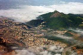 Pico do Jaraguá as seen from an aircraft | |
| Highest point | |
| Elevation | 1,135 m (3,724 ft) |
| Listing | List of mountains in Brazil |
| Coordinates | 23°27′30″S 46°45′55″W / 23.45833°S 46.76528°WCoordinates: 23°27′30″S 46°45′55″W / 23.45833°S 46.76528°W |
| Geography | |
 Pico do Jaraguá Location in southern Brazil | |
| Location | State of São Paulo, Brazil |
| Parent range | Serra da Cantareira |
| Climbing | |
| Easiest route | "Trilha da Bica" and "Trilha do Pai Zé" |
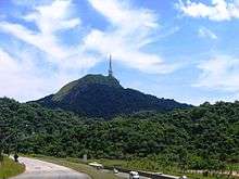
Pico do Jaraguá (Jaraguá Peak) is the highest mountain in the Brazilian city of São Paulo, at 1135 metres above sea level, located at the Serra da Cantareira. Jaraguá means Lord of the Valley in Tupi.[1]
History
In 1580, Afonso Sardinha was settled on the mountain, and found gold there. However, due to the indigenous people who lived there at that time, the mining only began ten years later, after numerous wars. The gold was explored until it was not possible to find it any more, by the 19th century.
In 1961, the Parque Estadual do Jaraguá (Jaraguá State Park) was created. Soon, TV Globo, Bandeirantes and TV Cultura were allowed to build their TV transmitting masts on the mountain. A 130-metre (430 ft) mast was placed on the highest peak, through a Globo-Bandeirantes partnership, while TV Cultura had its mast build on the nearby lower peak.
By 1994, the Parque Estadual do Jaraguá was nominated for World Heritage Site by UNESCO.[1]
References
- 1 2 "São Paulo 450 anos – O Pico do Jaraguá" (in Portuguese). Retrieved 2007-12-31.