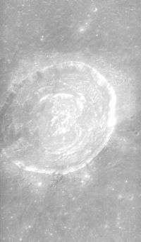
Picard (crater)
 Apollo 17 Mapping camera image | |
| Coordinates | 14°34′N 54°43′E / 14.57°N 54.72°ECoordinates: 14°34′N 54°43′E / 14.57°N 54.72°E |
|---|---|
| Diameter | 23 km |
| Depth | 2.4 km |
| Colongitude | 306° at sunrise |
| Eponym | Jean-Félix Picard |
Picard is a lunar impact crater that lies in Mare Crisium. It is the biggest non-flooded crater of this mare, being slightly larger than Peirce to the north-northwest. To the west is the almost completely flooded crater Yerkes. To east of Picard is the tiny Curtis. Also to the southwest is the Greaves-Lick crater pair. About 35–40 km southeast is the wrinkle ridge known as Dorsum Termier.
Picard is a crater from the Eratosthenian period, which lasted from 3.2 to 1.1 billion years ago. Inside Picard is a series of terraces that seismologists have attributed to a collapse of the crater floor. It has a cluster of low hills at the bottom.[1]
Names
The crater is named after the 17th-century French astronomer and geodesist Jean Picard.[2] Johannes Hevelius mapped it as "Alopecia Insula".[3] The crater didn't appear in Giovanni Riccioli's 1651 map, and was left unnamed for a few centuries.
Satellite craters
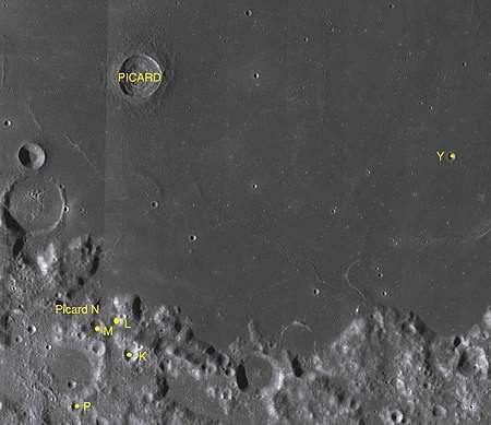
By convention these features are identified on lunar maps by placing the letter on the side of the crater midpoint that is closest to Picard.[4] Between 100 and 120 km south are five of its six satellite craters, the other being Picard Y is more than 125 km east.

| Picard | Coordinates | Diameter, km |
|---|---|---|
| K | 9°44′N 54°34′E / 9.73°N 54.56°E | 9 |
| L | 10°19′N 54°19′E / 10.32°N 54.31°E | 7 |
| M | 10°13′N 53°57′E / 10.21°N 53.95°E | 8 |
| N | 10°31′N 53°34′E / 10.52°N 53.57°E | 19 |
| P | 8°49′N 53°37′E / 8.82°N 53.62°E | 8 |
| Y | 13°11′N 60°16′E / 13.18°N 60.27°E | 4 |
The following craters have been renamed by the IAU.
- Picard G — see Tebbutt.
- Picard H — see Shapley.
- Picard X — see Fahrenheit.
- Picard Z — see Curtis.
References
- ↑ Moore, Patrick (2001). On the Moon. Sterling Publishing Co.. ISBN 0-304-35469-4.
- ↑ "Picard (crater)". Gazetteer of Planetary Nomenclature. USGS Astrogeology Research Program.
- ↑ Hevelius map of the Moon (1647)
- ↑ Bussey, B.; Spudis, P. (2004). The Clementine Atlas of the Moon. New York: Cambridge University Press. ISBN 0-521-81528-2.
External links
- LTO-62A1 Yerkes — L&PI topographic map
- "Picard (crater)". Gazetteer of Planetary Nomenclature. USGS Astrogeology Research Program.
- Map of the region
- Part of Picard crater: photo by Lunar Reconnaissance Orbiter with resolution 1,3 meters/pixel
- "Picard Crater Impact Melt". lroc.sese.asu.edu. 2012-12-11. Archived from the original on 2014-12-12. Retrieved 2014-12-12.
- "The Crater Picard: Strange Convergences". vgl.org. 1996-04-04. Archived from the original on 2007-10-25. Retrieved 2014-12-12.
- Picard in The-Moon Wiki
| Wikimedia Commons has media related to Picard (crater). |