Obor
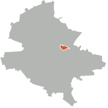


Obor is the name of a square and the surrounding district of Bucharest, the capital of Romania. There is also a Bucharest Metro station named Obor, which lies in this area.
Obor stands in the place of "Târgul Moșilor", a fair famous throughout Wallachia, which was held twice a week. In old Romanian "obor" meant enclosure, corral.
Located outside the city, in the 18th century, it was also the place for public hangings. About 20 Turks captured from wars were hanged here by the Romanians[1]
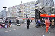
The Obor market (Piața Obor), the direct successor of the original fair, was, until 2007, Bucharest's largest public market. It covered about 16 city blocks and included a variety of indoor and outdoor market spaces, with goods ranging from compact discs to live chickens. Informally, the market spilled into the surrounding neighborhood, both in terms of street vendors and in terms of the nearby Magazin Universal ("Universal Store") named Bucur Obor, a large commercial building and housing estate (officially named the ALMO housing estate, built in 1975) that has been parcelled up into hundreds of small, independent retail stores. The market was demolished, not without public outcry, in order to pave the way for a modern market and a small park, thus ending a 300-year tradition.
Obor is near the quarter of Colentina and Moșilor.
In Romanian popular culture, it is referenced by Gică Petrescu in his song Uite-aşa aş vrea să mor, in which the artist playfully expresses his desire to be buried in a tavern in the area with a glass of red wine in his hand. Withn Bucharest dwellers, it has attained a reputation of a market of relatively cheap products, sometimes even of low quality. (citation needed)
References
- ↑ (in Romanian) Justiţie în Bucureştii de odinioară Magazin Istoric, no. 461. August 2005
| Sectors of Bucharest |  | |
|---|---|---|
| Districts (quarters) |
| |
| Squares | ||
| Major streets | ||
| Hills | ||
| Rivers | ||
| Lakes |
| |
| Parks and forests | ||
| See also | ||
Coordinates: 44°27′1.52″N 26°7′47.03″E / 44.4504222°N 26.1297306°E