Berceni, Bucharest
Berceni is a district (cartier in Romanian) of southern Bucharest.
Berceni is also locally known as the place through where the wind comes in Bucharest.
Location
Geographically, it has a trapezoidal shape, bordered by Oltenitei Road and Turnu Magurele Street in the north and south, respectively. Built during the 1960s, it is a typical Communist-era working class district, lacking any major green spaces or cultural attractions. It has a population of roughly 110,000.
Some map would be really useful here. https://www.google.com/maps/place/Berceni,+Bucharest/@44.3862626,26.1020178,14.78z/data=!4m5!3m4!1s0x40b1fe41c69f7dc9:0x7aa404e0b3338385!8m2!3d44.3892215!4d26.1182032
Etymology
It is believed that the name comes from the hussars of Miklós Bercsényi, who were first mentioned after the suppression of the Hungarian Kuruc War led by Francis II Rákóczi (at beginning of the 18th century). They settled in the neighborhood of Bucharest. Another theory claims that the name comes from an archaic Romanian word for tax collector.
Other
There is also a village of Berceni, which is situated to the south and is outside Bucharest city limits.
Gallery
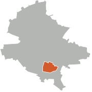 Berceni on the map of Bucharest
 Bucharest Sefard Jewish cemetery
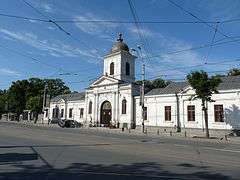 Bellu cemetery
 Boulevard C-tin Brancoveanu, Berceni
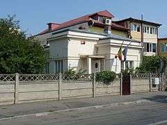 George Bacovia memorial museum
| Sectors of Bucharest |  | |
|---|---|---|
| Districts (quarters) |
| |
| Squares | ||
| Major streets | ||
| Hills | ||
| Rivers | ||
| Lakes |
| |
| Parks and forests | ||
| See also | ||
Coordinates: 44°23′18.73″N 26°7′4.17″E / 44.3885361°N 26.1178250°E