Peytonsville, Tennessee
| Peytonsville, Tennessee | |
|---|---|
| Unincorporated community | |
 Peytonsville, Tennessee  Peytonsville, Tennessee | |
| Coordinates: 35°49′06″N 86°46′46″W / 35.81833°N 86.77944°WCoordinates: 35°49′06″N 86°46′46″W / 35.81833°N 86.77944°W | |
| Country | United States |
| State | Tennessee |
| County | Williamson |
| Elevation | 791 ft (241 m) |
| Time zone | UTC-6 (Central (CST)) |
| • Summer (DST) | UTC-5 (CDT) |
| Area code(s) | 615 |
| GNIS feature ID | 1297292[1] |
Peytonsville (formerly known as Snatch and Snatchett) is an unincorporated community in Williamson County, Tennessee.[1] Peytonsville is located near Interstate 840 8.9 miles (14.3 km) southeast of Franklin. The Nathaniel Smithson House, which is listed on the National Register of Historic Places, is located in Peytonsville.[2]
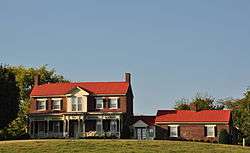
The Nathaniel Smithson House is located in Peytonsville.
Notable people
- Tom Little, editorial cartoonist
References
- 1 2 "Peytonsville". Geographic Names Information System. United States Geological Survey.
- ↑ National Park Service (2010-07-09). "National Register Information System". National Register of Historic Places. National Park Service.
Municipalities and communities of Williamson County, Tennessee, United States | ||
|---|---|---|
| Cities | ||
| Towns | ||
| Unincorporated communities | ||
| Footnotes | ‡This populated place also has portions in an adjacent county or counties | |
This article is issued from
Wikipedia.
The text is licensed under Creative Commons - Attribution - Sharealike.
Additional terms may apply for the media files.