Pertunmaa
| Pertunmaa | ||
|---|---|---|
| Municipality | ||
| Pertunmaan kunta | ||
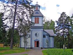 Pertunmaa Church | ||
| ||
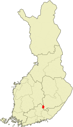 Location of Pertunmaa in Finland | ||
| Coordinates: 61°30′10″N 026°28′45″E / 61.50278°N 26.47917°ECoordinates: 61°30′10″N 026°28′45″E / 61.50278°N 26.47917°E | ||
| Country |
| |
| Region | Southern Savonia | |
| Sub-region | Mikkeli sub-region | |
| Charter | 1926 | |
| Government | ||
| • Municipal manager | Juha Torniainen | |
| Area (2018-01-01)[1] | ||
| • Total | 454.20 km2 (175.37 sq mi) | |
| • Land | 374.48 km2 (144.59 sq mi) | |
| • Water | 79.7 km2 (30.8 sq mi) | |
| Area rank | 207th largest in Finland | |
| Population (2018-08-31)[2] | ||
| • Total | 1,713 | |
| • Rank | 277th largest in Finland | |
| • Density | 4.57/km2 (11.8/sq mi) | |
| Population by native language[3] | ||
| • Finnish | 98.9% (official) | |
| • Swedish | 0.2% | |
| • Others | 0.9% | |
| Population by age[4] | ||
| • 0 to 14 | 13.6% | |
| • 15 to 64 | 58.7% | |
| • 65 or older | 27.7% | |
| Time zone | UTC+2 (EET) | |
| • Summer (DST) | UTC+3 (EEST) | |
| Municipal tax rate[5] | 20% | |
| Website | www.pertunmaa.fi | |

Pertunmaa is a municipality of Finland located in the province of Eastern Finland which is part of the Southern Savonia region. The municipality has a population of 1,713 (31 August 2018)[2] and covers an area of 454.20 square kilometres (175.37 sq mi) of which 79.7 km2 (30.8 sq mi) is water.[1] The population density is 4.57 inhabitants per square kilometre (11.8/sq mi).
Neighbour municipalities are Hartola, Heinola, Hirvensalmi, Mäntyharju and Joutsa.
The language of the municipality is Finnish.
Culture
It's said that Pertunmaa's culture is mixed with these regions, Southern Savonia and Päijänne Tavastia.
Itä-Häme newspaper is published also in Pertunmaa.
Some villages
Kuortti, Lihavanpää, Mansikkamäki, Nipuli, Ruorasmäki, Joutsjärvi, Hölttä, Hartosenpää, Kuhajärvi, Karankamäki, and Kälkyttä.
References
- 1 2 "Area of Finnish Municipalities 1.1.2018" (PDF). National Land Survey of Finland. Retrieved 30 January 2018.
- 1 2 "Ennakkoväkiluku kuukausittain sukupuolen mukaan alueittain, elokuu 2018" (in Finnish). Statistics Finland. Retrieved 21 October 2018.
- ↑ "Population according to language and the number of foreigners and land area km2 by area as of 31 December 2008". Statistics Finland's PX-Web databases. Statistics Finland. Retrieved 29 March 2009.
- ↑ "Population according to age and gender by area as of 31 December 2008". Statistics Finland's PX-Web databases. Statistics Finland. Retrieved 28 April 2009.
- ↑ "List of municipal and parish tax rates in 2011". Tax Administration of Finland. 29 November 2010. Retrieved 13 March 2011.
External links
![]()
- Municipality of Pertunmaa – Official website, english, finnish and russian languages
| Municipalities |  | |
|---|---|---|
| Former municipalities |
| |