Perth Stadium Bus Station
.JPG)
Perth Stadium Bus Station
Perth Stadium Bus Station is a Transperth bus station, located at the southern edge of Perth Stadium in Burswood, Western Australia.[1] It has 22 stands[2] and is served by eight Transperth special event routes.
Bus routes
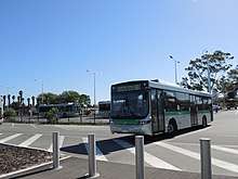
A route 661 bus to Elizabeth Quay at the bus station
As of 2018, nine bus routes service Perth Stadium Bus Station.[3] These routes connect suburbs without train lines to the stadium.[4]
With the opening of the Matagarup Bridge on 14 July 2018, route 661[lower-alpha 1] was adjusted to service the Matagarup Bridge bus stands on Nelson Avenue, East Perth. The opening of the bridge also caused the other suburban bus routes to change their bus stands at the bus station.[6]
| Stop | Route | Destination / description | Notes |
|---|---|---|---|
| Stands 1, 2 & 3 | 659 | Fremantle Station via Canning Highway and Canning Bridge bus station[7][8] | |
| Stands 4 & 5 | 658 | Hamilton Hill via Kardinya Park and Booragoon bus station[9][8] | |
| Stands 6 & 7 | No scheduled services[8] | ||
| Stands 8 & 9 | 657 | Curtin University Bus Station[10][8] | |
| Stands 10 & 11 | 656 | Canning Vale via Bentley Plaza[11][8] | |
| Stands 12 & 13 | 654 | Ellenbrook Town Centre via Bassendean Station[12][8] | |
| Stands 14 & 15 | 652 | Mirrabooka bus station via Alexander Drive[13][8] | |
| Stands 16 & 17 | 653 | Morley bus station via Beaufort Street[14][8] | |
| Stands 18–22 | 650 | Karrinyup bus station via Innaloo[15][8] |
Notes
- ↑ Route 661 previously connected Elizabeth Quay Bus Station to Perth Stadium Bus Station[5]
References
- ↑ Transperth. "Map of Perth Stadium Bus Station". Government of Western Australia. Archived from the original on 23 January 2018. Retrieved 22 January 2018.
- ↑ Perpitch, Nicolas (19 January 2018). "How to get to Perth Stadium: Train, bus, car or walk — the best options to get there and home". ABC News. Australian Broadcasting Corporation. Archived from the original on 22 January 2018. Retrieved 22 January 2018. Additional archives: 22 January 2018.
- ↑ Transperth. "Optus Stadium". Government of Western Australia. Archived from the original on 22 January 2018. Retrieved 22 January 2018. Additional archives: 22 January 2018.
- ↑ Johns, David (22 January 2018). "How to get to Optus Stadium in Perth using public transport: bus and train times". Southern Gazette. Community News Group. Archived from the original on 23 January 2018. Retrieved 23 January 2018. Additional archives: 23 January 2018.
- ↑ Transperth. "Route 661". Government of Western Australia. Retrieved 22 January 2018.
- ↑ "Transperth Optus Stadium". Transperth. 14 July 2018.
- ↑ Transperth. "Route 659". Government of Western Australia. Retrieved 22 January 2018.
- 1 2 3 4 5 6 7 8 9 Transperth. "Perth Stadium Bus Station Stand Allocations". Government of Western Australia. Archived from the original (PDF) on 6 August 2018. Retrieved 6 August 2018.
- ↑ Transperth. "Route 658". Government of Western Australia. Retrieved 22 January 2018.
- ↑ Transperth. "Route 657". Government of Western Australia. Retrieved 22 January 2018.
- ↑ Transperth. "Route 656". Government of Western Australia. Retrieved 22 January 2018.
- ↑ Transperth. "Route 654". Government of Western Australia. Retrieved 22 January 2018.
- ↑ Transperth. "Route 652". Government of Western Australia. Retrieved 22 January 2018.
- ↑ Transperth. "Route 653". Government of Western Australia. Retrieved 22 January 2018.
- ↑ Transperth. "Route 650". Government of Western Australia. Retrieved 22 January 2018.
- Lim, Kristie (5 January 2018). "New bus services a game changer for sport at Perth Stadium". Eastern Reporter. Community News Group. Archived from the original on 23 January 2018. Retrieved 23 January 2018. Additional archives: 23 January 2018.
- White, Simon (15 January 2018). "Optus Stadium open day - how to get there and back". The West Australian. Archived from the original on 23 January 2018. Retrieved 23 January 2018.
External links

| Central area | |
|---|---|
| Northern area | |
| Eastern area | |
| Western area | |
| South eastern area | |
| Southern area | |
| Former stations | |
| Bus routes | |
Bus stations marked with | |
This article is issued from
Wikipedia.
The text is licensed under Creative Commons - Attribution - Sharealike.
Additional terms may apply for the media files.