Peoples, Kentucky
| Peoples, Kentucky | |
|---|---|
| Unincorporated community | |
 Peoples  Peoples | |
| Coordinates: 37°17′22″N 84°03′12″W / 37.28944°N 84.05333°WCoordinates: 37°17′22″N 84°03′12″W / 37.28944°N 84.05333°W | |
| Country | United States |
| State | Kentucky |
| County | Jackson |
| Elevation | 971 ft (296 m) |
| Time zone | UTC-5 (Eastern (EST)) |
| • Summer (DST) | UTC-4 (EDT) |
| Area code(s) | 606 |
| GNIS feature ID | 514489[1] |
Peoples is an unincorporated community in Jackson County, Kentucky, United States. Peoples is located at the junction of Kentucky Route 2002 and Kentucky Route 3630 5 miles (8.0 km) west-southwest of Annville.[2] Peoples had a post office until it closed on January 3, 2004.[3][4] The community has the name of the local Peoples family.[5]
References
- ↑ "Peoples". Geographic Names Information System. United States Geological Survey.
- ↑ State Primary Road System: Jackson County (PDF) (Map). Kentucky Transportation Cabinet. 2011. Retrieved January 6, 2013.
- ↑ United States Postal Service (2012). "USPS - Look Up a ZIP Code". Retrieved 2012-02-15.
- ↑ "Postmaster Finder - Post Offices by ZIP Code". United States Postal Service. Retrieved January 6, 2013.
- ↑ Moyer, Armond; Moyer, Winifred (1958). The origins of unusual place-names. Keystone Pub. Associates. p. 100.
Municipalities and communities of Jackson County, Kentucky, United States | ||
|---|---|---|
| City | 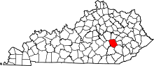 | |
| CDP | ||
| Unincorporated communities | ||
This article is issued from
Wikipedia.
The text is licensed under Creative Commons - Attribution - Sharealike.
Additional terms may apply for the media files.