Penny Lane, Liverpool
Coordinates: 53°23′13″N 2°55′10″W / 53.38694°N 2.91944°W
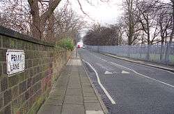 A view down Penny Lane at the opposite end from the bus terminus, approaching the junction with Greenbank Road near to Sefton Park | |
| Postal code | L18 1DE |
|---|---|
Penny Lane is a street in the city of Liverpool in the north of England. The name also applies to the area surrounding the thoroughfare. The street is off the A562 road. During the twentieth century, it was the location for one of the main bus termini in Liverpool. The street gained international renown in 1967 when the English rock group the Beatles released their song "Penny Lane", written in tribute to the band members' upbringing in Liverpool.
History
Penny Lane was named after James Penny, an eighteenth-century slave trader.[1] As with many of the era's industrialists, and Liverpool itself, Penny became wealthy through the international slave trade, for which the port city served as an important stopover between the African continent and America.[2]
After the city's expansion, Penny Lane was the location for a significant bus terminus for several routes, and buses with "Penny Lane" displayed were common throughout Liverpool. The name Penny is also used for the area that surrounds its junction with Smithdown Road, Smithdown Place (where the terminus was located) and Allerton Road, including a busy shopping area. It was the terminus for the number 46 and 99 bus routes to Walton, Old Swan and the city centre. At the other end from its junction on Smithdown Road, the street leads down to the University of Liverpool's student halls of residence, near Sefton Park.
The street and the bus depot became a place of international interest as a result of the Beatles' song "Penny Lane".[3] Released in February 1967, the song was a number 1 hit in many charts around the world. The fireman and fire engine referred to in the lyrics are the fire station at Mather Avenue, which is close to Penny Lane.[4] The terminus at Penny Lane included a purpose-built bus shelter, with a waiting room and toilets. The shelter is located on its own island, which is "the shelter in the middle of a roundabout" referred to in the song.[5]
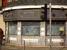
Towards the end of the 1970s, businesses in Penny Lane included Penny Lane Records and a wine bar known as Harper's Bizarre, now called Penny Lane Wine Bar. The latter was formerly a doctors' surgery, previously Drs Walton, Endbinder and Partners; the practice moved to Smithdown Place in the 1980s. Following privatisation, the Merseyside Passenger Transport Executive bus depot, slightly up the hill past Bioletti's barbershop, was demolished and replaced with a shopping precinct complete with a supermarket and a public house. In the 1980s, the bus shelter was bought privately and converted to the Sergeant Pepper's Bistro. It subsequently closed and remained out of commission until 2015, when it underwent refurbishment with the aim of reopening as a restaurant, although it was still not open as of October 2016.[5][6][7]
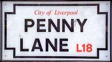
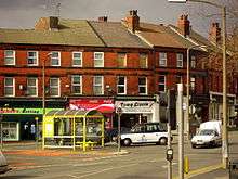
The street has long been sought out by Beatles fans touring Liverpool. In the past, street signs saying "Penny Lane" were constant targets of tourist theft and had to be continually replaced. City officials gave up and simply began painting the street name on the sides of buildings. This practice was stopped in 2007 and more theft-resistant "Penny Lane" street signs have since been installed, although some are still stolen.[3] The Penny Lane area has acquired a level of trendiness and desirability. The "alternative" businesses (wholefood outlets, charity shops), the now expanded array of cafés, bars, bistros and takeaway food emporiums, as well as traditional businesses (WHSmith and Clarke's cake shop), make the neighbourhood the most sought-after among Liverpool's large student population.
In July 2006, a Liverpool councillor proposed renaming certain streets because their names were linked to the slave trade. One such street was Penny Lane, given James Penny's past and his strong opposition to abolitionism.[8] Ultimately, city officials decided to forgo the name change and entirely re-evaluate renaming.[2]
References
- ↑ Pandey, Swati (16 July 2006). "Beneath the blue suburban skies". Los Angeles Times. Retrieved 23 February 2011.
- 1 2 Associated Press (10 July 2006). "Liverpool Won't Rename Penny Lane, Despite Slavery Ties". Fox News Channel. Retrieved 11 May 2018.
- 1 2 Turner, Steve (2009). A Hard Day's Write: The Stories Behind Every Beatles Song. MJF Books. p. 187. ISBN 1-60671-109-1.
- ↑ Miles, Barry. Paul McCartney: Many Years From Now.
- 1 2 Graves, Steve (5 July 2013). "Liverpool's Beatles-inspired Sergeant Pepper's Bistro to reopen with added second floor". Liverpool Echo. Retrieved 1 October 2016.
- ↑ ashwom (1 November 2015). "There Are Places I Remember: Penny Lane: Remastered Promotional film 2015". Beatlesliverpoollocations.blogspot.co.uk. Retrieved 1 October 2016.
- ↑ Martin (2016-10-31). "25 BEATLES SITES AND ACTIVITIES IN LIVERPOOL". cityxplora.com. Retrieved 2017-01-18.
- ↑ Coslett, Paul (15 February 2007). "Penny Lane". bbc.co.uk. Retrieved 11 May 2018.
| Wikimedia Commons has media related to Penny Lane, Liverpool. |