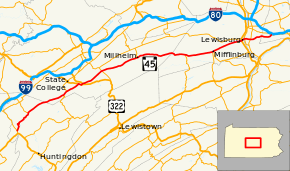
Pennsylvania Route 45
| |||||||
|---|---|---|---|---|---|---|---|
 | |||||||
| Route information | |||||||
| Maintained by PennDOT | |||||||
| Length | 86 mi[1] (138 km) | ||||||
| Major junctions | |||||||
| West end |
| ||||||
|
| |||||||
| East end |
| ||||||
| Location | |||||||
| Counties | Huntingdon, Centre, Union, Northumberland, Montour | ||||||
| Highway system | |||||||
| |||||||

Pennsylvania Route 45 (PA 45) is an 86-mile-long (138 km) state highway located in central Pennsylvania, United States. PA 45 is called the Purple Heart Highway. The western terminus of the route is at Pennsylvania Route 453 in the Morris Township near the community of Water Street. The eastern terminus is at Pennsylvania Route 642 west of the small town of Mooresburg.
History
From approximately 1830 to 1903, the section between Lewisburg and Mifflinburg was owned and operated by the Lewisburg and Mifflinburg Turnpike Company.[2] The section west of Mifflinburg (formerly Youngmanstown) was built by the Bellefonte, Aaronsburg and Youngmanstown Turnpike Company, chartered in 1825.[3]
When Pennsylvania's "traffic routes" were established in 1925, PA 45 was originally signed from Herndon to Easton.[4] The 1928 revision expanded this route westward; PA 45 was signed on two different sections, the connection between them being signed as part of US 120 (later US 122, now PA 405, PA 147, and PA 61). The "middle" section was signed from Water Street to Montandon, between Milton and Northumberland,[5] and the east section from Ashland to Easton.[6]
In 1928, the route was under construction from Indianland to Beersville and completed the following year on the Ashland to Easton section. In 1930, the route was paved from Lehigh Gap to Indianland on the eastern section. In 1934, the eastern terminus was moved from Walnut Street to 13th Street in Easton.
In 1932, a western section of PA 45 was opened from Belsano to US 22 near Sankertown and Cresson. The route replaced US 422 from Belsano to Ebensburg and US 22 from Ebensburg to Cresson when those designations were placed on a straighter route.[7] In 1936, the eastern terminus of the middle section was moved from Montandon to Mausdale. In 1946, the eastern terminus of the western section was truncated from Cresson to Ebensburg. Until 1952, the middle section entered Mooresburg on a different route. In 1951, construction began on a bypass which opened in 1952. In 1955, the eastern terminus in the eastern section was moved from 13th Street to Third Street in Easton.[8]
Until 1961, there was a break between Mausdale and Ashland, that was connected when PA 54 was truncated to Mausdale. This resulted in PA 45 being a continuous route between Altoona and Easton. This change was undertaken as part of a plan to simplify route numbers across the state.[9] Also in 1961, the western section of PA 45 was decommissioned; the piece of PA 45 between Belsano and Nanty Glo became part of an extension of PA 933[10][11] and is currently part of PA 271.
In 1962, the route was changed from going into State College via US 322 and then PA 26, to go straight from PA 26 to Boalsburg. On May 9, 1966, the eastern terminus of PA 45 was cut back from Easton to its current location at PA 642 in Mooresburg. The former alignment east of Mooresburg became PA 642 between Mooresburg and Mausdale, an extended PA 54 between Mausdale and Nesquehoning, solely US 209 between Nesquehoning and Weissport, and newly-designated PA 248 between Weissport and Easton. This change was made to remove several concurrencies, while the extension of PA 54 to replace PA 45 between Mausdale and Nesquehoning was made to provide a direct connection with I-80.[12][13][14]
Major intersections
| County | Location | mi | km | Destinations | Notes |
|---|---|---|---|---|---|
| Huntingdon | Morris Township | 0.0 | 0.0 | Western terminus of PA 45 Truck | |
| Franklin Township | 7.8 | 12.6 | Southern terminus of PA 350, eastern terminus of PA 45 Truck | ||
| Centre | Ferguson Township | 19.5 | 31.4 | Western terminus of concurrency | |
| 20.9 | 33.6 | Eastern terminus of concurrency | |||
| Harris Township | 25.1 | 40.4 | Western terminus of concurrency | ||
| 25.9 | 41.7 | Eastern terminus of concurrency | |||
| 26.4 | 42.5 | Interchange, access to westbound US 322 and access from eastbound US 322 | |||
| Potter Township | 33.3 | 53.6 | |||
| Penn Township | 44.4 | 71.5 | Southern terminus of PA 445 | ||
| Union | Hartley Township | 59.1 | 95.1 | Northern terminus of PA 235 | |
| Mifflinburg | 67.4 | 108.5 | Northern terminus of PA 104, western terminus of PA 45 Truck/PA 304 Truck | ||
| 67.9 | 109.3 | Western terminus of PA 304 | |||
| Lewisburg | 76.6 | 123.3 | |||
| Northumberland | West Chillisquaque Township | 77.5 | 124.7 | ||
| 79.2 | 127.5 | Interchange | |||
| Montour | Liberty Township | 86.0 | 138.4 | ||
1.000 mi = 1.609 km; 1.000 km = 0.621 mi
| |||||
Special routes
PA 45 Truck (Mifflinburg)
| |
|---|---|
| Location | Mifflinburg, Pennsylvania |
| Existed | 1969–present |
Pennsylvania Route 45 Truck is a 2-mile-long (3.2 km) truck route in Mifflinburg, Union County, Pennsylvania. Narrow streets within the borough are avoided by this designation, and a complicated intersection with Pennsylvania Route 304, which does not contain turning lanes, is bypassed. The route begins at PA 304 south of Mifflinburg by heading west along SR 3004 (Red Ridge Road) before turning north onto Pennsylvania Route 104 and ending at PA 45. The truck route is signed as Pennsylvania Route 304 Truck in the opposite direction.
PA 45 Truck (Huntingdon County)
| |
|---|---|
| Location | Huntingdon County, Pennsylvania |
| Existed | 1969–present |
At mile 2.4, just south of Spruce Creek, a very old overpass, constructed from blocks of stone, carries Norfolk Southern's Pittsburgh Line over PA 45. Passage of large trucks is impossible as it allows only 8'2" of clearance, and the speed limit on the associated hairpin turn is 10 mph. Pennsylvania Route 45 Truck is a 17-mile-long (27 km) truck route designed to avoid this bottleneck, other sharp turns, and steep grades along mainline PA 45 in western Huntingdon County, Pennsylvania. The route is somewhat antiquated, concurrent entirely with other routes, and significantly longer than the twisty mainline. Traveling mostly in Franklin Township and Warriors Mark Township, the route begins in the west by branching northbound along Pennsylvania Route 453, before continuing east along Pennsylvania Route 550, and traveling south along Pennsylvania Route 350 to meet up with its parent.
PA 45 Truck (Centre County)
| |
|---|---|
| Location | Centre County, Pennsylvania |
| Existed | 2013–present |
Pennsylvania Route 45 Truck is a truck route of PA 45 that bypasses a weight-restricted bridge over Pine Creek on which trucks over 33 tons and combination loads over 40 tons are prohibited. The route follows PA 144, PA 192, and PA 445. It was signed in 2013.[15]
See also


References
- ↑ Google (June 27, 2013). "Pennsylvania Route 45" (Map). Google Maps. Google. Retrieved June 27, 2013.
- ↑ Oliphant, J. Orin; Merrill W. Linn (April 1948). "THE LEWISBURG AND MIFFLINBURG TURNPIKE COMPANY". Pennsylvania History. 15 (2): 86–119. JSTOR 27766883.
- ↑ Snyder, Charles (2000). Union County, Pennsylvania: A Celebration of History. Penn State Press. p. 53.
- ↑ Cram's Official Paved Road Map of East Central States (Map). George F. Cram Co., archived by Harold Cramer, mapsofpa.com. 1927. Retrieved 2011-01-08.
- ↑ 1929 Map of Pennsylvania (middle segment) (Map). Pennsylvania Department of Highways. 1929. Archived from the original on 2011-05-26. Retrieved 2011-01-08.
- ↑ 1929 Map of Pennsylvania (eastern segment) (Map). Pennsylvania Department of Highways. 1929. Archived from the original on 2011-05-26. Retrieved 2011-01-08.
- ↑ General Highway Map of Cambria County, Pennsylvania (first sheet) (PDF) (Map). Pennsylvania Department of Highways. 1941. Retrieved 2011-01-08.
- ↑ "Pennsylvania Highways: PA 1 - PA 50 (PA 45)". Jeffrey J. Kitsko, pahighways.com. Retrieved 2011-01-08.
- ↑ "Part of Route 54 Changed to 45". Shamokin News-Dispatch. March 31, 1961. p. 1. Retrieved August 16, 2015 – via Newspapers.com.

- ↑ "Pennsylvania Highways: PA 901 - PA 950 (PA 933)". Jeffrey J. Kitsko, pahighways.com. Retrieved 2011-01-08.
- ↑ General Highway Map of Cambria County, Pennsylvania (first sheet) (PDF) (Map). Pennsylvania Department of Highways. 1962. Retrieved 2011-01-08.
- ↑ "State Highway Traffic Route Changes Announced". Jim Thorpe Times-News. May 5, 1966. p. 1. Retrieved November 13, 2017 – via Newspapers.com.
- ↑ General Highway Map of Montour County, Pennsylvania (PDF) (Map). Pennsylvania Department of Highways. 1966. Retrieved 2011-01-08.
- ↑ Official Map of Pennsylvania (PDF) (Map). Pennsylvania Department of Highways. 1970. Retrieved November 13, 2017.
- ↑ "Risk-Based Bridge Postings - State and Local Bridges" (PDF). Pennsylvania Department of Transportation. October 8, 2013. Retrieved May 19, 2016.
External links
Route map:
| Wikimedia Commons has media related to Pennsylvania Route 45. |