Pennington Flash Country Park
| Pennington Flash Country Park | |
|---|---|
 | |
| Type | Country park |
| Location | Leigh, Greater Manchester |
| Operated by | Wigan Council |
| Open | All year |
Pennington Flash Country Park is a 200-hectare (490-acre) country park located between Lowton and Leigh in Greater Manchester, England.
History
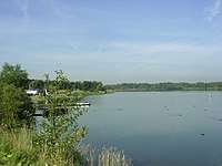
A Flash is a water-filled hollow formed by subsidence. Pennington Flash is a 70-hectare (170-acre) lake created at the turn of the 20th century by coal mining subsidence, mainly from Bickershaw Colliery.[1] Before the flash the area contained two farms, both of which were abandoned in the early 1900s due to flooding.[2] During the 1960s and 1970s the idea to convert the flash for recreation was emerging and the country park was opened in 1981.[2]
Nature
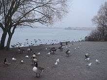
Pennington Flash Country Park is a nature reserve. Over 230 bird species have been recorded on site including black-faced bunting, nightingale, marsh harrier, spoonbill and Leach's storm-petrel. Additionally, a wide variety of butterflies, dragonflies and damselflies can be spotted in the area.[1]
Facilities
Facilities include a small information centre, a nine-hole municipal golf course, a car park, a children's play area, toilets, picnic and recreation areas, eight bird hides,[3] fishing on certain shores, sailing, windsurfing and rowing through Leigh and Lowton Sailing Club.[4] There is a network of tracks and footpaths suitable for walkers, cyclists, horse riders, joggers and wheelchair users.[5] A Parkrun takes place every Saturday morning.[6]
References
- 1 2 Pennington Flash, RSPB Liverpool, retrieved 2011-01-03
- 1 2 "Pennington Flash - History - LLSC". 29 January 2012.
- ↑ "Pennington Flash - Country Park in Leigh".
- ↑ Leigh and Lowton Sailing Club, Leigh and Lowton Sailing Club, retrieved 2010-03-10
- ↑ Park Information, archived from the original on 2011-07-26, retrieved 2012-06-30
- ↑ "Pennington Flash parkrun - Pennington Flash parkrun". www.parkrun.org.uk.
External links
| Wikimedia Commons has media related to Pennington Flash Country Park. |
Coordinates: 53°29′10″N 2°32′50″W / 53.486079°N 2.547154°W