Penig
| Penig | ||
|---|---|---|
| ||
 Penig Location of Penig within Mittelsachsen district 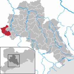 | ||
| Coordinates: 50°56′1″N 12°42′21″E / 50.93361°N 12.70583°ECoordinates: 50°56′1″N 12°42′21″E / 50.93361°N 12.70583°E | ||
| Country | Germany | |
| State | Saxony | |
| District | Mittelsachsen | |
| Government | ||
| • Mayor | Thomas Eulenberger (CDU) | |
| Area | ||
| • Total | 63.31 km2 (24.44 sq mi) | |
| Elevation | 208 m (682 ft) | |
| Population (2017-12-31)[1] | ||
| • Total | 8,804 | |
| • Density | 140/km2 (360/sq mi) | |
| Time zone | CET/CEST (UTC+1/+2) | |
| Postal codes | 09322 | |
| Dialling codes | 037381 | |
| Vehicle registration | FG | |
| Website | www.penig.de | |

Penig (German pronunciation: [ˈpeːnɪç]) is a town in the district of Mittelsachsen, in the Free State of Saxony, Germany. It is situated on the river Zwickauer Mulde, 19 km northwest of Chemnitz. The old and the new castle were owned by the House of Schönburg from 1378 until 1945. Penig housed a concentration camp during World War II.
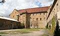 The Old Castle
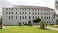 The New Castle
People
References
- ↑ "Aktuelle Einwohnerzahlen nach Gemeinden 2017] (Einwohnerzahlen auf Grundlage des Zensus 2011)" (PDF). Statistisches Landesamt des Freistaates Sachsen (in German). October 2018.
This article is issued from
Wikipedia.
The text is licensed under Creative Commons - Attribution - Sharealike.
Additional terms may apply for the media files.