Penhill
| Penhill | |
|---|---|
 | |
| Highest point | |
| Elevation | 553 m (1,814 ft) |
| Prominence | 124 m (407 ft) |
| Coordinates | 54°16′30.8″N 1°56′07.1″W / 54.275222°N 1.935306°WCoordinates: 54°16′30.8″N 1°56′07.1″W / 54.275222°N 1.935306°W |
| Geography | |
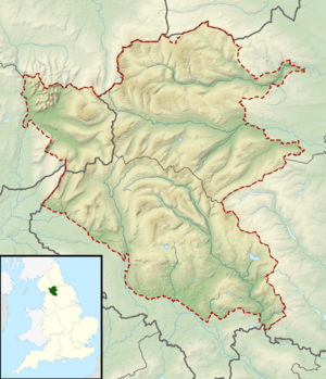 Penhill Location of Penhill in Yorkshire Dales | |
| Location | North Yorkshire, England |
| Parent range | Pennines, Yorkshire Dales |
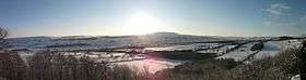
Penhill (526 metres high at the trig point, 553 metres at Height of Hazely) is a prominent hill in the Pennines in North Yorkshire, England. It forms a ridge that commands the southern side of Wensleydale and the northern side of Coverdale. Its concave shape was formed during the last ice age, when glaciers carved Wensleydale into a U-shape. The summit plateau has a trig point, small tarns on the peat moor, and, visible from the valley floor, a beacon at its eastern end, part of the large network built to warn of a Spanish invasion.
Penhill is accessed by public footpaths from the village of West Witton, by a bridleway from a minor road between West Witton and Melmerby, or over open access land from the south.
Although Penhill is not a very high hill, its position near the mouth of Wensleydale makes it visible from a considerable distance - from the North York Moors across the Vale of York, as well as from many points in the dale.
Like Pendle Hill, Penhill is a pleonastic name consisting of Brittonic (penn) and Old English (hyll) words for "hill".[1]
References
External links
![]()
- "Yorkshire Dales walk - West Witton". Yorkshire Life. 11 August 2014.