Pelican, Louisiana
| Pelican, Louisiana | |
|---|---|
| Unincorporated community | |
 Pelican  Pelican | |
| Coordinates: 31°52′57″N 93°35′10″W / 31.88250°N 93.58611°WCoordinates: 31°52′57″N 93°35′10″W / 31.88250°N 93.58611°W | |
| Country | United States |
| State | Louisiana |
| Parish | DeSoto |
| Elevation | 322 ft (98 m) |
| Time zone | UTC-6 (Central (CST)) |
| • Summer (DST) | UTC-5 (CDT) |
| ZIP code | 71063 |
| Area code(s) | 318 |
| GNIS feature ID | 538048[1] |
Pelican is an unincorporated community in DeSoto Parish, Louisiana, United States. Pelican is located at the junction of Louisiana highways 483 and 513, 12.6 miles (20.3 km) south-southeast of Mansfield.[2] Pelican has a post office with ZIP code 71063.[3][4]
References
- ↑ "Pelican". Geographic Names Information System. United States Geological Survey.
- ↑ DeSoto Parish West Section (PDF) (Map). Louisiana Department of Transportation and Development. 2012. Retrieved December 21, 2012.
- ↑ United States Postal Service (2012). "USPS - Look Up a ZIP Code". Retrieved 2012-02-15.
- ↑ "Postmaster Finder - Post Offices by ZIP Code". United States Postal Service. Retrieved December 21, 2012.
Municipalities and communities of DeSoto Parish, Louisiana, United States | ||
|---|---|---|
| City | 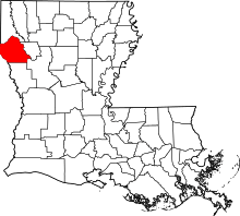 | |
| Towns | ||
| Villages | ||
| CDPs | ||
| Other unincorporated communities | ||
This article is issued from
Wikipedia.
The text is licensed under Creative Commons - Attribution - Sharealike.
Additional terms may apply for the media files.