Peel, Arkansas
| Peel, Arkansas | |
|---|---|
| Unincorporated community | |
 Peel, Arkansas  Peel, Arkansas | |
| Coordinates: 36°25′56″N 92°46′08″W / 36.43222°N 92.76889°WCoordinates: 36°25′56″N 92°46′08″W / 36.43222°N 92.76889°W | |
| Country | United States |
| State | Arkansas |
| County | Marion |
| Elevation | 938 ft (286 m) |
| Time zone | UTC-6 (Central (CST)) |
| • Summer (DST) | UTC-5 (CDT) |
| ZIP code | 72668 |
| Area code(s) | 870 |
| GNIS feature ID | 77972[1] |
Peel is an unincorporated community in Marion County, Arkansas, United States. Peel is located on Arkansas Highway 125, 8 miles (13 km) east of Lead Hill. Peel has a post office with ZIP code 72668.[2]
References
Municipalities and communities of Marion County, Arkansas, United States | ||
|---|---|---|
| Cities | 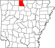 | |
| Town | ||
| Unincorporated communities | ||
This article is issued from
Wikipedia.
The text is licensed under Creative Commons - Attribution - Sharealike.
Additional terms may apply for the media files.