Peanut, Arkansas
| Peanut, Arkansas | |
|---|---|
| Unincorporated community | |
 Peanut, Arkansas  Peanut, Arkansas | |
| Coordinates: 35°40′31″N 93°42′18″W / 35.67528°N 93.70500°WCoordinates: 35°40′31″N 93°42′18″W / 35.67528°N 93.70500°W | |
| Country | United States |
| State | Arkansas |
| County | Franklin |
| Elevation | 846 ft (258 m) |
| Time zone | UTC-6 (Central (CST)) |
| • Summer (DST) | UTC-5 (CDT) |
| GNIS feature ID | 73027[1] |
Peanut is an unincorporated community in Franklin County, Arkansas, United States.[1]
The remote settlement is located near the Mulberry River, within the Ozark–St. Francis National Forest.
Prior to 1945, the settlement was called "Taft", and Taft at one time had a post office.[2]
In 1975, there was one house located in Peanut.[2]
References
- 1 2 U.S. Geological Survey Geographic Names Information System: Peanut
- 1 2 Scott, Charles (July 1, 1975). "Correspondence with U.S. Geological Survey". U.S. Geological Survey.
Municipalities and communities of Franklin County, Arkansas, United States | ||
|---|---|---|
| Cities | 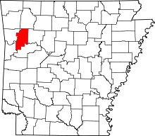 | |
| Town | ||
| Unincorporated communities | ||
| Ghost town | ||
This article is issued from
Wikipedia.
The text is licensed under Creative Commons - Attribution - Sharealike.
Additional terms may apply for the media files.