Arrondissement of Gex
| Gex | |
|---|---|
| Arrondissement | |
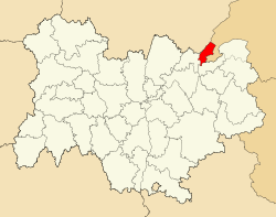 Location of Gex in Auvergne-Rhône-Alpes | |
| Country | France |
| Region | Auvergne-Rhône-Alpes |
| Department | Ain |
| Communes | 27 |
| Subprefecture | Gex |
| Area¹ | |
| • Total | 405 km2 (156 sq mi) |
| Population (2014) | |
| • Total | 89,200 |
| • Density | 220/km2 (570/sq mi) |
| ¹ French Land Register data, which exclude lakes, ponds, and glaciers larger than 1 km² as well as the estuaries of rivers. | |
The arrondissement of Gex is an arrondissement of France in the Ain department in the Auvergne-Rhône-Alpes region. It approximately corresponds to the historical region of the Pays de Gex. Since the January 2017 reorganization of the arrondissements of Ain, it has 27 communes.[1]
Composition
Cantons
The cantons of the arrondissement of Gex are:
Communes
The communes of the arrondissement of Gex, and their INSEE codes, are:
- Cessy (01071)
- Challex (01078)
- Chevry (01103)
- Chézery-Forens (01104)
- Collonges (01109)
- Crozet (01135)
- Divonne-les-Bains (01143)
- Échenevex (01153)
- Farges (01158)
- Ferney-Voltaire (01160)
- Gex (01173)
- Grilly (01180)
- Léaz (01209)
- Lélex (01210)
- Mijoux (01247)
- Ornex (01281)
- Péron (01288)
- Pougny (01308)
- Prévessin-Moëns (01313)
- Saint-Genis-Pouilly (01354)
- Saint-Jean-de-Gonville (01360)
- Sauverny (01397)
- Ségny (01399)
- Sergy (01401)
- Thoiry (01419)
- Versonnex (01435)
- Vesancy (01436)
Pays de Gex
The Pays de Gex (literally, land of Gex) was a part of the County of Geneva during the High Middle Ages. It is notable for the fact that it changed hands between Switzerland, the Duchy of Savoy and France several times. The final decision about its political affiliation was made by the Treaty of Paris (1815), which split it between France and Switzerland. The French part is now the Arrondissement of Gex, while the Swiss part is now the northwestern part of the Canton of Geneva.
References
- ↑ "Arrêté n° 16-542, p 746" (PDF). Retrieved 2017-07-20.