Pavia Township, Bedford County, Pennsylvania
| Pavia Township, Pennsylvania | |
|---|---|
| Township | |
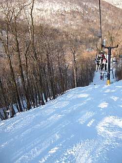 Ski hill at Blue Knob State Park | |
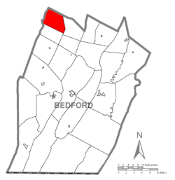 Map of Bedford County, Pennsylvania highlighting Pavia Township | |
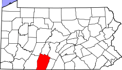 Map of Bedford County, Pennsylvania | |
| Country | United States |
| State | Pennsylvania |
| County | Bedford |
| Settled | 1794 |
| Incorporated | 1834, as Union Township |
| Renamed | c. 1993 – 1995, as Pavia Township |
| Area[1] | |
| • Total | 22.15 sq mi (57.36 km2) |
| • Land | 22.14 sq mi (57.35 km2) |
| • Water | 0.01 sq mi (0.01 km2) |
| Population (2010) | |
| • Total | 295 |
| • Estimate (2016)[2] | 276 |
| • Density | 12.46/sq mi (4.81/km2) |
| Time zone | UTC-5 (Eastern (EST)) |
| • Summer (DST) | UTC-4 (EDT) |
| Area code(s) | 814 |
| FIPS code | 42-009-58492 |
Pavia Township is a township in Bedford County, Pennsylvania, United States. The population was 295 at the 2010 census.[3] The township was known as Union Township until it changed its name to Pavia Township between 1993 and 1995.[4][5]
Geography
Pavia Township is located in the northwest corner of Bedford County, bordered to the west by Cambria County and to the north by Blair County. A large portion of the township is occupied by Blue Knob State Park, including the 3,130-foot (950 m) summit of Blue Knob, the second highest peak in Pennsylvania. Pennsylvania Route 869 is the only major road that passes through the township.
According to the United States Census Bureau, the township has a total area of 22.2 square miles (57.4 km2), of which 0.004 square miles (0.01 km2), or 0.02%, is water.
Demographics
| Historical population | |||
|---|---|---|---|
| Census | Pop. | %± | |
| 2010 | 295 | — | |
| Est. 2016 | 276 | [2] | −6.4% |
| U.S. Decennial Census[6] | |||
As of the census[7] of 2000, there were 325 people, 122 households, and 91 families residing in the township. The population density was 14.8 people per square mile (5.7/km²). There were 191 housing units at an average density of 8.7/sq mi (3.4/km²). The racial makeup of the township was 99.69% White and 0.31% Asian. Hispanic or Latino of any race were 0.31% of the population.
There were 122 households, out of which 33.6% had children under the age of 18 living with them, 62.3% were married couples living together, 8.2% had a female householder with no husband present, and 25.4% were non-families. 15.6% of all households were made up of individuals, and 6.6% had someone living alone who was 65 years of age or older. The average household size was 2.66 and the average family size was 2.97.
In the township the population was spread out, with 24.6% under the age of 18, 6.8% from 18 to 24, 31.1% from 25 to 44, 26.2% from 45 to 64, and 11.4% who were 65 years of age or older. The median age was 37 years. For every 100 females there were 112.4 males. For every 100 females age 18 and over, there were 100.8 males.
The median income for a household in the township was $35,000, and the median income for a family was $38,750. Males had a median income of $25,000 versus $21,250 for females. The per capita income for the township was $16,115. About 5.8% of families and 9.1% of the population were below the poverty line, including 7.0% of those under age 18 and 19.0% of those age 65 or over.
References
- ↑ "2016 U.S. Gazetteer Files". United States Census Bureau. Retrieved Aug 13, 2017.
- 1 2 "Population and Housing Unit Estimates". Retrieved June 9, 2017.
- ↑ "Geographic Identifiers: 2010 Demographic Profile Data (G001): Pavia township, Bedford County, Pennsylvania". U.S. Census Bureau, American Factfinder. Retrieved March 6, 2014.
- ↑ McClelland, Ed (September 2, 2009). "Bedford County Pennsylvania, Township Map". The USGenWeb Project. Retrieved October 25, 2015.
Note: Union Township's name was changed in 1993 to Pavia Township.
- ↑ "Some Facts About the Present-Day Townships That Descend From Old-Greenfield". Old-Greenfield Township Historical Society. Retrieved October 25, 2015.
Pavia Township is located in Bedford County. She began her existence as Union Township and only recently (in 1995) was renamed Pavia Township.
- ↑ "Census of Population and Housing". Census.gov. Retrieved June 4, 2016.
- ↑ "American FactFinder". United States Census Bureau. Retrieved 2008-01-31.
Municipalities and communities of Bedford County, Pennsylvania, United States | ||
|---|---|---|
| Boroughs | | |
| Townships | ||
| CDPs | ||
| Unincorporated communities | ||
| Footnotes | ‡This populated place also has portions in an adjacent county or counties | |
Coordinates: 40°14′30″N 78°33′29″W / 40.24167°N 78.55806°W