Earlston, Pennsylvania
| Earlston, Pennsylvania | |
|---|---|
| Census-designated place | |
 Earlston Location within the state of Pennsylvania | |
| Coordinates: 40°0′22″N 78°22′12″W / 40.00611°N 78.37000°WCoordinates: 40°0′22″N 78°22′12″W / 40.00611°N 78.37000°W | |
| Country | United States |
| State | Pennsylvania |
| County | Bedford |
| Township | West Providence |
| Area | |
| • Total | 1.1 sq mi (2.8 km2) |
| • Land | 1.1 sq mi (2.8 km2) |
| • Water | 0.0 sq mi (0.0 km2) |
| Population (2010) | |
| • Total | 1,122 |
| • Density | 1,039/sq mi (401.2/km2) |
| Time zone | UTC-5 (Eastern (EST)) |
| • Summer (DST) | UTC-4 (EDT) |
| GNIS feature ID | 1173111[1] |
Earlston is a census-designated place[2] in West Providence Township, Bedford County, Pennsylvania, in the United States. The population was 1,122 as of the 2010 census.[3] It is located just across the Raystown Branch of the Juniata River from the borough of Everett.
References
- ↑ U.S. Geological Survey Geographic Names Information System: Earlston, Pennsylvania
- ↑ "Archived copy". Archived from the original on 2013-12-21. Retrieved 2013-02-10.
- ↑ "Geographic Identifiers: 2010 Demographic Profile Data (G001): Earlston CDP, Pennsylvania". U.S. Census Bureau, American Factfinder. Retrieved March 6, 2014.
Municipalities and communities of Bedford County, Pennsylvania, United States | ||
|---|---|---|
| Boroughs | 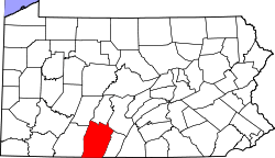 | |
| Townships | ||
| CDPs | ||
| Unincorporated communities | ||
| Footnotes | ‡This populated place also has portions in an adjacent county or counties | |
This article is issued from
Wikipedia.
The text is licensed under Creative Commons - Attribution - Sharealike.
Additional terms may apply for the media files.