Paucar del Sara Sara Province
| Paucar del Sara Sara | |
|---|---|
| Province | |
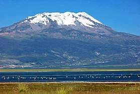 Sara Sara, the highest mountain of the province | |
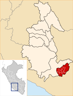 Location of Paucar del Sara Sara in the Ayacucho Region | |
| Country | Peru |
| Region | Ayacucho |
| Capital | Pausa |
| Government | |
| • Mayor | José Felix Rosenthal Quispe |
| Area | |
| • Total | 2,096.92 km2 (809.63 sq mi) |
| Population | |
| • Total | 10,610 |
| • Density | 5.1/km2 (13/sq mi) |
| UBIGEO | 0508 |
Paucar del Sara Sara Province is a province located in the south-eastern corner of the Ayacucho Region of Peru. It is one of eleven provinces that make up the region. The province has a population of 10,610 inhabitants 2005 census. It is bounded to the north and west by the Parinacochas Province and to the south and east by the Arequipa Region. The capital of this province is the city of Pausa.
Geography
The highest mountain in the province is Sara Sara at 5,505 m (18,061 ft) on the border to the Parinacochas Province. Other mountains are listed below:[1]
- Aklla Wasi
- Ancha Qalla
- Anilluyuq
- Aqu
- Aqu Q'asa
- Awkiwatu
- Chulluni
- Chururu P'ukru
- Hatun Aqu
- Ichhu Pata
- Jamati Wañusqa
- Kisu Rumi
- Kuntur Sirka
- Lujmani
- Pampa Wasi
- Puka Puka
- Puka Q'asa
- Puka Urqu
- Puma Ranra
- Putaqa
- Qaqa Mach'ay
- Qarwayuq
- Qillqata
- Qiñwa Pampa
- Qiñwa P'unqu
- Quriwayrachina
- Q'ala Urqu
- Q'illu Pata
- Ranra
- Runa Runa
- Runtu
- Sara Sara
- Saywayuq
- Sumaq Pampa
- Tinku
- Wamani
- Wamanripa Q'asa
- Warmi P'unqu
- Wilachiri
- Yana Mach'ay
- Yana Ranra
- Yana Sallani
- Yana Urqu
Political division
The province extends over an area of 2,096.92 square kilometres (809.63 sq mi) and is divided into ten districts. The districts, with their capitals in parenthesis, are:
- Colta (Colta)
- Corculla (Corculla)
- Lampa (Lampa)
- Marcabamba (Marcabamba)
- Oyolo (Oyolo)
- Pararca (Pararca)
- Pausa (Pausa)
- San Javier de Alpabamba (San Javier de Alpabamba)
- San José de Ushua (San José de Ushua)
- Sara Sara District (Qilcata)
Ethnic groups
The people in the province are mainly indigenous citizens of Quechua descent. Quechua is the language which the majority of the population (50.15%) learnt to speak in childhood, 49.36 % of the residents started speaking using the Spanish language (2007 Peru Census).[2]
See also
Sources
- ↑ escale.minedu.gob.pe - UGEL map of the Paucar del Sara Sara Province (Ayacucho Region)
- ↑ inei.gob.pe Archived 2013-01-27 at the Wayback Machine. INEI, Peru, Censos Nacionales 2007
| |
|---|---|
Coordinates: 15°16′47″S 73°20′45″W / 15.27972°S 73.34583°W