Cangallo Province
| Cangallo | |
|---|---|
| Province | |
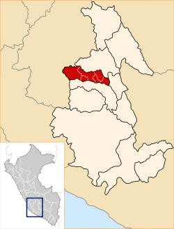 Location of Cangallo in the Ayacucho Region | |
| Country | Peru |
| Region | Ayacucho |
| Capital | Cangallo |
| Government | |
| • Mayor | Percy Colos Ayala |
| Area | |
| • Total | 191,617 km2 (73,984 sq mi) |
| Elevation | 2,577 m (8,455 ft) |
| Population | |
| • Total | 36,977 |
| • Density | 0.19/km2 (0.50/sq mi) |
| UBIGEO | 0502 |
| Website | http://www.municangallo.gob.pe/ |

The Cangallo Province is a province located in the Ayacucho Region of Peru. It is one of the eleven that make up the region. The province has a population of 36,977 inhabitants as of census 2005. The capital of the province is the city of Cangallo.
Boundaries
- North: Huamanga Province
- East: Vilcas Huamán Province
- South: Víctor Fajardo Province
- West: Huancavelica Region
Geography
One of the highest mountains of the province is Chiqllarasu at 5,167 m (16,952 ft). Other mountains are listed below:[1]
- Anta Sirka
- Antap'iti
- Aqchi Mach'ay
- Arpachayuq
- Asulqucha
- Atuq Wachana
- Ayapa Uman
- Chaku
- Chawpi Urqu
- Ch'uspi
- Hatun Pata
- Hatun Urqu
- Hatun Qaqa
- Huch'uy Puka Q'asa
- Kawra Qaqa
- Kiswara
- Kuntur Q'asa
- K'ichki
- Mach'ayniyuq
- Machu Uqhu
- Millpu
- Misapata
- Pirwaylla
- Puka Kunka
- Puka Mach'ay
- Puka Urqu
- Phutunqu
- P'iti Q'asa
- P'ukru
- Qarampa
- Qarwa Q'asa
- Qullpa Pata
- Q'illu Q'asa
- Q'illu Wayta
- Rayusqa
- Rit'ipata
- Ruphasqa
- Sasaylla
- Saywa
- Saywa Q'asa
- Suyuqucha
- Tampuchayuq
- Taruka Punta
- Usnu
- Waranwallqa
- Waychaw Pata
- Wayra Punku
- Wisk'acha Urqu
- Yana Allpa
- Yana Chaka
- Yana Phiruru
- Yana Qaqa
- Yanaqucha
- Yawarqucha
- Yawlillayuq
Political division
The province extends over an area of 1,916.17 square kilometers (739.84 sq mi) and is divided into six districts:
- Cangallo (Cangallo)
- Chuschi (Chuschi)
- Los Morochucos (Pampa Cangallo)
- María Parado de Bellido (Pomabamba)
- Paras (Paras)
- Totos (Totos)
Ethnic groups
The people in the province are mainly indigenous citizens of Quechua descent. Quechua is the language which the majority of the population (90.14%) learnt to speak in childhood, 9.62% of the residents started speaking using the Spanish language (2007 Peru Census).[2]
Archaeology
Various archaeological sites of the province were declared a National Cultural Heritage. Some of the most important sites of the province are listed below:[3][4]
- Anta Q'asa, Apachita Achamarka, Apachita Awqanqa, Apachita Manchayniyuq, Kunkachayuq, Llaqta Punta, Marka, Ñawpa Llaqta, Pirwaylla, Turichayuq, Wakuya, Waman Pukyu, Wantay Llamuqu, Waña Q'asa and Wichinka in the Paras District
- Añas Qullpa, Kullku Wasi, Pillwa Pampa and Pisqu Pata in the Totos District
See also
sources
- ↑ escale.minedu.gob.pe - UGEL maps of the Cangallo Province and the Huamanga Province (Ayacucho Region)
- ↑ inei.gob.pe Archived January 27, 2013, at the Wayback Machine. INEI, Peru, Censos Nacionales 2007
- ↑ El Peruano, Normas Legales, p. 243766 and 243767, May 8, 2003, Lima
- ↑ Gobierno Regional de Ayacucho, Plan de Desarrollo Turístico de la Región Ayacucho 2004 – 2014, Aprobado mediante Ordenanza de Consejo Regional N° 03 - 04 - GRA/PRES
External links
- (in Spanish) Portal de Cangallo
- Primera web de Cangallo
| |
|---|---|
Coordinates: 13°37′43″S 74°08′39″W / 13.628658°S 74.144097°W