Pathein
| Pathein ပုသိမ်မြို့ Bassein | |
|---|---|
| City | |
 | |
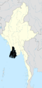
 Pathein Location of Pathein, Myanmar (Burma) | |
| Coordinates: 16°46′N 94°43′E / 16.767°N 94.717°E | |
| Country |
|
| Region |
|
| District | Pathein District |
| Township | Pathein Township |
| Population (2014) | |
| • Total | 287,071 |
| • Ethnicities | Bamar, Burmese Indians, Kayin |
| • Religions | Buddhism |
| Time zone | UTC+6.30 (MST) |
| Area code(s) | 42[1] |
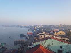
Pathein (Burmese: ပုသိမ်မြို့; MLCTS: pu. sim mrui., Burmese pronunciation: [pəθèiɴ mjo̰]; Mon: ဖာသဳ, [pha sɛm]), formerly called Bassein, is the largest city and the capital of the Ayeyarwady Region, Myanmar (Burma). It is located 190 km (120 mi) west of Yangon on the bank of the Pathein River (Bassein), which is a western branch of the Irrawaddy River.[2], the city has a population of 237,089 (2017 census). Although once part of the Mon kingdom, Pathein has few ethnic Mon residents today. The majority are of Bamar, Burmese Indians and Karen ethnicity. There are, however, notable minority Rakhine.
Etymology
The city's name is believed to derive from the Mon name, ဖာသီ ([pha sɛm]).[3] The name was corrupted to Bassein during the British colonial period.
An alternate theory holds that the city's name comes from the classical name of Pathein, Kusimanagara, a name used by ancient writings and the Kalyani inscriptions.[4] Pathein itself is a corruption of Mon "Kuthen," which itself is a contraction of Kusimanagara.[4] This is supported by the fact that the Portuguese call Pathein "Cosmim."[4]
History
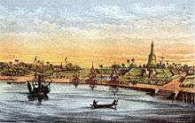
Pathein was part of the Mon kingdom. The British built a fort and established a garrison in 1826, after the First Anglo-Burmese War. The 1983 census recorded a population of 144,092.
Geography and economy
Lying at the western edge of the Ayeyarwady River delta, on the Pathein (Ngawan) River 118 miles (190 km) west of Yangon, Pathein is accessible to large vessels and despite its distance from the ocean, it is the most important delta port outside of Yangon. The city is also a terminus of a branch of the main railroad line which connects it to Hinthada, Letpadan and Yangon. In the 1990s, the road network along the Irrawaddy to Monywa was improved.[2]
The coastline along the Bay of Bengal is surrounded by the Arakan Mountains. In the area is Inye Lake, 1.5 miles (2.4 km) long and 1 mile (1.6 km) wide, which is known for its fishing. There is also an offshore reef at Diamond Island that is popular with bathers. Diamond Island is also noted as a turtle breeding ground.[2]

The city is a rice-milling and export centre. Aside from several rice mills, the town has numerous sawmills and umbrella workshops. The colourful handmade parasols made in Pathein are widely known throughout Burma.[2] They are known locally as "Pathein Hti".[5] Pathein is also known for its pottery and colourful hand-made baskets and buckets.
The surrounding area of Pathein are employed in agriculture and cultivate sesames, groundnuts, jute, maize, pulse_(legume)s, tobacco, chilies etc.[5]
Climate
| Climate data for Pathein | |||||||||||||
|---|---|---|---|---|---|---|---|---|---|---|---|---|---|
| Month | Jan | Feb | Mar | Apr | May | Jun | Jul | Aug | Sep | Oct | Nov | Dec | Year |
| Record high °C (°F) | 39.9 (103.8) |
40.8 (105.4) |
42.0 (107.6) |
42.9 (109.2) |
42.6 (108.7) |
41.2 (106.2) |
39.5 (103.1) |
40.1 (104.2) |
40.5 (104.9) |
41.4 (106.5) |
40.3 (104.5) |
38.7 (101.7) |
42.9 (109.2) |
| Average high °C (°F) | 30.7 (87.3) |
33.3 (91.9) |
35.2 (95.4) |
36.4 (97.5) |
34.3 (93.7) |
30.2 (86.4) |
29.7 (85.5) |
30.2 (86.4) |
30.4 (86.7) |
32.0 (89.6) |
31.5 (88.7) |
30.9 (87.6) |
32.1 (89.7) |
| Average low °C (°F) | 16.6 (61.9) |
18.9 (66) |
22.3 (72.1) |
23.8 (74.8) |
25.2 (77.4) |
25.4 (77.7) |
24.4 (75.9) |
24.3 (75.7) |
24.1 (75.4) |
23.9 (75) |
21.6 (70.9) |
17.5 (63.5) |
22.3 (72.2) |
| Record low °C (°F) | 10.0 (50) |
12.3 (54.1) |
15.2 (59.4) |
17.8 (64) |
18.8 (65.8) |
20.5 (68.9) |
21.2 (70.2) |
21.4 (70.5) |
20.3 (68.5) |
16.4 (61.5) |
13.3 (55.9) |
11.7 (53.1) |
10 (50) |
Pathein has a Tropical monsoon climate (Am) according to the Köppen climate classification system. Pathein experiences a sustained period of extraordinary rainfall from June through August. The dry season which runs from December through April, generally sees noticeably cooler temperatures than the remainder of the year.
Landmarks
Pathein has a scenic waterfront and many Buddhist temples, including the main sight of Shwemokhtaw Pagoda.
Notable sites
- Tagaung Mingala Pagoda[6]
- Settayaw Paya
- Clock Tower
- St Peter's Cathedral
- Pathein Cultural Museum
Education
The city is home to the Pathein Education College for elementary teachers and Pathein University for arts and science students. The Computer University (Pathein) which is administered by Ministry of Science and Technology offers both undergraduate and graduate programs in computer science, and computer technology. Technological University (Pathein) which was founded in 1999, offers engineering courses.
Sports
The 6,000-seat Ayar Stadium is one of the main venues for popular local football tournaments. The stadium is the home of Ayeyawady United F.C., a Myanmar National League (MNL) football club.
Health care
_-_panoramio_(4).jpg)
Pathein General Hospital serves people in Pathein and its surrounding districts.
See also
References
| Wikivoyage has a travel guide for Pathein. |
| Wikimedia Commons has media related to Pathein. |
| Wikisource has the text of the 1911 Encyclopædia Britannica article Bassein. |
- ↑ "Myanmar Area Codes". Retrieved 2009-04-10.
- 1 2 3 4 "Pathein". Encyclopædia Britannica. Retrieved August 21, 2009.
- ↑ Dictionary of Modern Spoken Mon by H.L. Shorto (1962, Oxford University Press)
- 1 2 3 James Gray, ed. (1892). Buddhaghosuppatti. London: Luzac & Company. p. 11.
- 1 2 "Pathein (Bassein)". Journeysmyanmar.com. Retrieved August 21, 2009.
- ↑ Planet, Lonely. "Tagaung Mingala Zeditaw in Pathein, Myanmar (Burma)". Lonely Planet. Retrieved 2017-09-09.
Coordinates: 16°46′27″N 94°43′54″E / 16.77417°N 94.73167°E